
Geoscience
GIS Map Gallery
Geographic Information System
Geoscientific Maps
Surficial Geology Compilation Map Series (SGCMS)
Compiled by G.L.D. Matile and G.R. Keller
Manitoba Geological Survey
Manitoba Growth, Enterprise and Trade
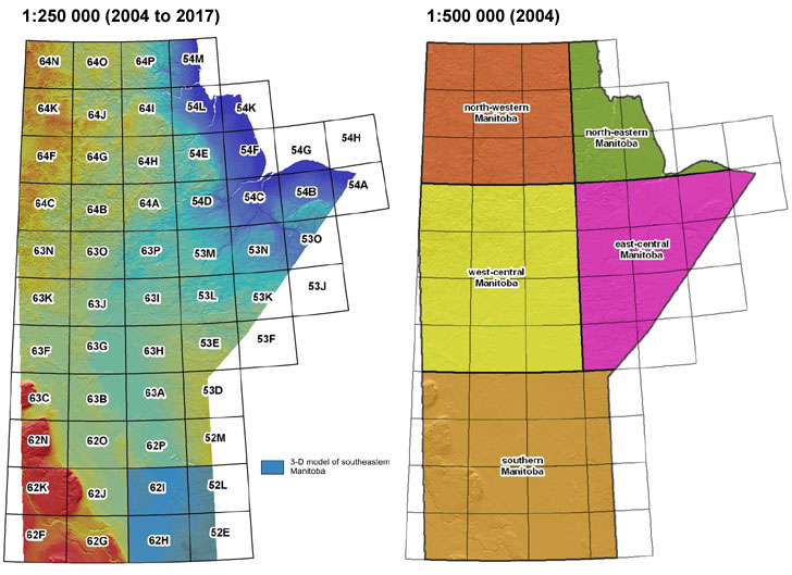
1:250 000 scale seamless maps updated digitally in October 2017 for parts of NTS areas 53L/M/N, 54L/M, 63J/K/N/O, 64A/G/H/I/N/P. Data presented at 1:250 000 scale, though some data was compiled at scales as detailed as 1:50 000. For areas with very detailed data, use of the GIS Map Gallery or shapefiles are recommended.
Introduction
The Surficial Geology Compilation Map Series (SGCMS) addresses an increasing demand for consistent surficial geology information for applications such as groundwater protection, industrial mineral management, protected lands, basic research, mineral exploration, engineering, and environmental assessment. In addition, aggregate resources depicted on the maps are applicable to the heavy construction and building industries.
The SGCMS provides seamless province-wide coverage at scales of 1:250 000 and 1:500 000 including the NTS and regional map sheets for southern Manitoba (south of 53°N) released in 2004. A final compilation at 1:1 000 000 was released in 2007 and supersedes the original Surficial Geological Map of Manitoba (Nielsen et al., 1981). An updated seamless 1:1 000 000 was released in 2017 and is available on the GIS Map Gallery.
The regional 1:500 000 scale maps north of 53°N and the 1:250 000 scale maps south of 53°N include
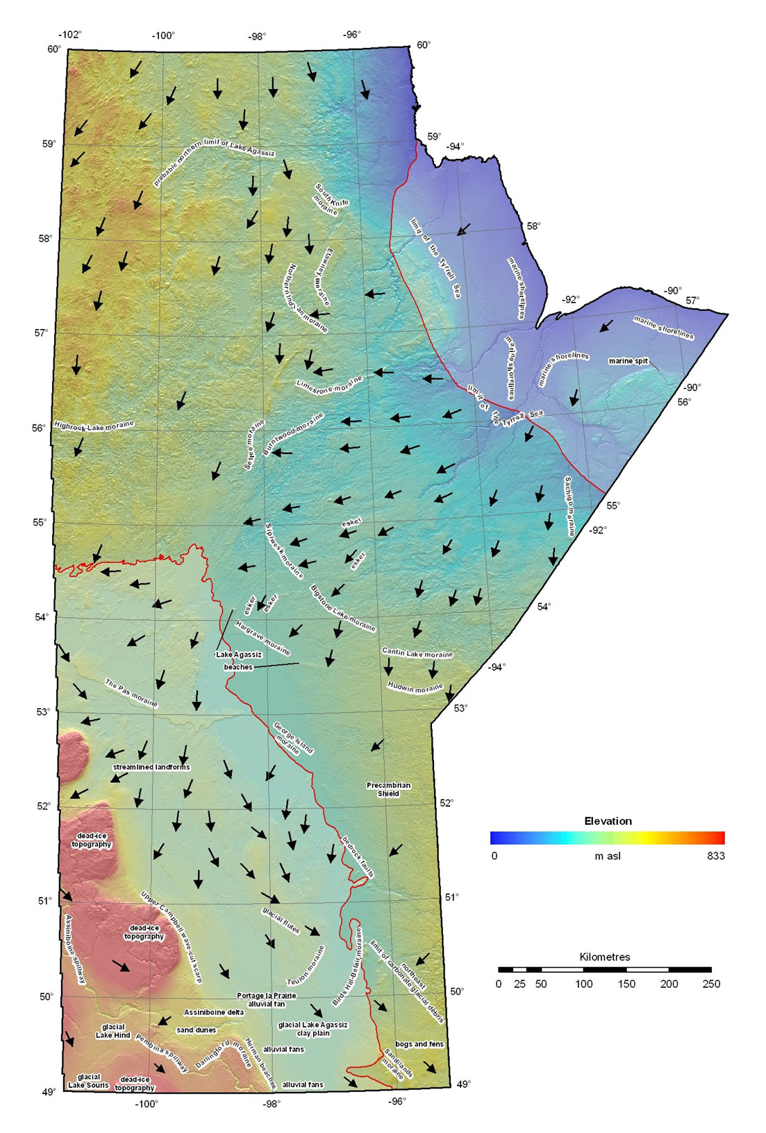
- surficial geology polygons draped on hill shaded topographic relief derived from the Shuttle Radar Topography Mission Digital Elevation Model (SRTM DEM) (United States Geological Survey, 2002)
- a brief description of the Quaternary landscape of northern or southern Manitoba,
- major landforms of Manitoba with specific reference to the glacial ice flow direction, and
- a paleogeographic reconstruction of late glacial events in Manitoba.
The two-sided 1:1 000 000 scale map includes all information above as well as:
- a full colour graphic description of map units which includes photographs and diagrams to define each unit in lay terms (ROCK – R, TILL – T, GLACIOFLUVIAL – G, GLACIOLACUSTRINE – L, GLACIOMARINE – M, ALLUVIUM – A, EOLIAN – E, COLLUVIUM – C, MODERN SHORELINE SEDIMENTS – Lm, ORGANIC – O)
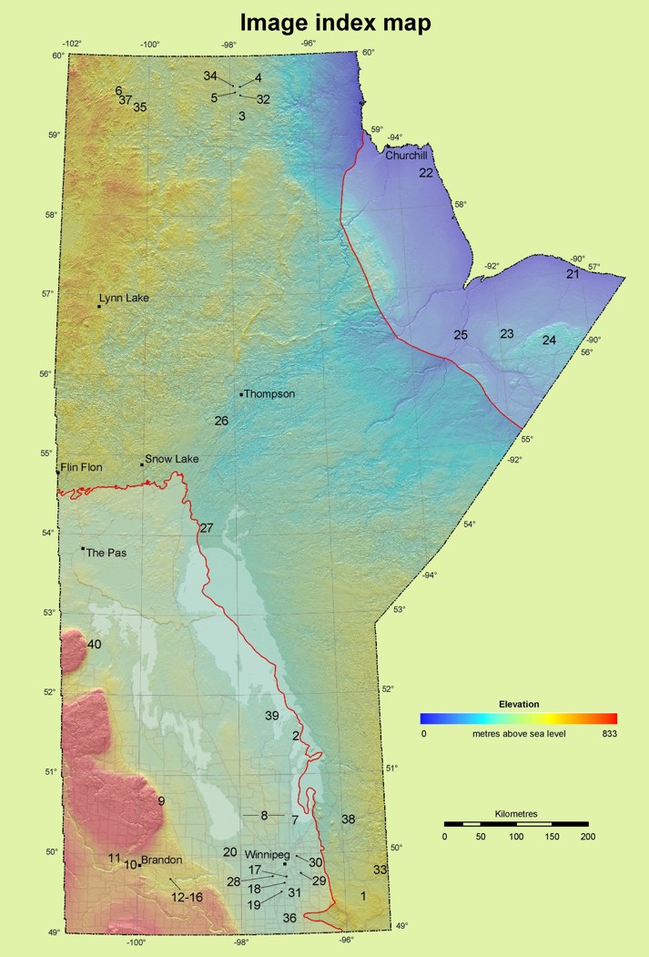
- an index map showing the location of each of these photographs
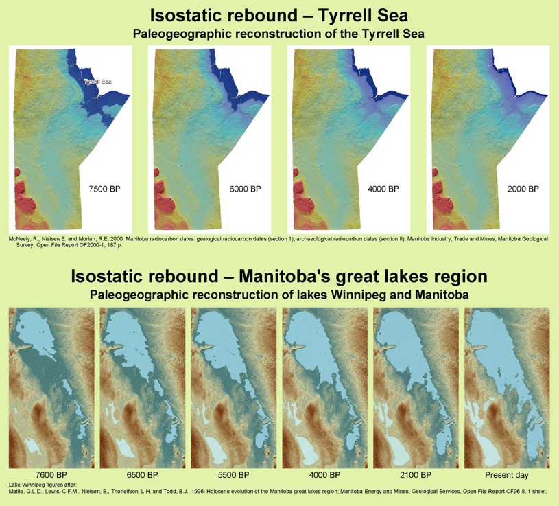
- diagrams depicting the effect of isostatic rebound on Manitoba’s Tyrrell Sea and Great Lakes regions
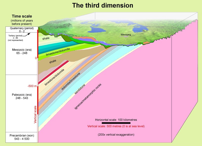
- a look into the 3rd dimension by way of a 3D block diagram cut through the two largest cities in the province.
Click on map sheet for more options
(hover over links below to view release date)
Surficial Geology Compilation Map Series coverage at 1:1 million scale:
 Map front (2007) (PDF in a 122 MB zip file)
Map back (2007) (PDF in a 88 MB zip file)
Zipped Shapefiles (2017) (195 MB zip file) -- This is a seamless map for the entire province, compiled at scales between 1:250 000 and 1: 50 000 scale. For areas with very detailed data, use of the GIS Map Gallery or shapefiles are recommended.
A zip file is available for download containing the SGCMS ArcView legend file and the SGCMS legend link database. Instructions for their use are included in the zip file.
Methodology
Paper copies of the most current and detailed surficial geology maps of various scales published by the Geological Survey of Canada and/or the Manitoba Geological Survey (MGS) were digitized for this compilation. Polygons for several areas were derived from digital geological maps. Digital polygons derived from soils mapping were used to fill gaps in the geological mapping. Edge-matching of adjoining map sheets was based on data from the SRTM DEM as interpreted by the MGS. Other polygon gaps and inconsistencies were modified in a similar manner. The surficial geology (coloured) is draped over a shaded topographic relief map (grey tones) derived from the SRTM DEM.
All source map units were converted into a standardized legend and housed in a database that can be queried to retrieve the original interpretation which can be used to colour maps based on a variety of material characteristics. The 1:250 000 scale maps reference the source of the polygons.
Print and web formats
Paper copies of the 1:500 000 scale maps and the 1:250 000 scale maps for NTS areas south of 53°N are available from MGS Publication Sales (see contact information below). The 1:250 000 scale maps north of 53°N are available in digital format only. All SGCMS maps are available on-line for viewing or free download by clicking on the images above, or as interactive maps through the GIS Map Gallery.
Suggested references
To assist users in referencing SGCMS maps, all maps provide a suggested reference for each 1:250 000 and 1:500 000 map sheet as a stand-alone product, regardless of the format (PDF, paper, ESRI® shapefiles) or access point (DVD or web). The following examples, using the Norway House NTS 63H map sheet, are provided to assist users in referencing SGCMS maps based on format and access point (highlighted text changes with NTS or regional map sheet).
PDF from the SGCMS DVD
Matile, G.L.D. and Keller, G.R. 2006: Surficial geology of the Norway House map sheet (NTS 63H), Manitoba; Map SG-63H in Surficial Geology Compilation Map Series of Manitoba (2nd ed.), Manitoba Science, Technology, Energy and Mines, Manitoba Geological Survey, Surficial Geology Compilation Map Series SG-CMS, 1 DVD, 1:250 000 scale.
PDF downloaded from web
Matile, G.L.D. and Keller, G.R. 2006: Surficial geology of the Norway House map sheet (NTS 63H), Manitoba; Manitoba Science, Technology, Energy and Mines, Manitoba Geological Survey, Surficial Geology Compilation Map SG-63H, scale 1:250 000, URL <https://www.gov.mb.ca/iem/geo/gis/sgcms/pdfs/SG-63H_2006.pdf> [November 2006].
Zipped shapefiles downloaded from web
Matile, G.L.D. and Keller, G.R. 2006: Surficial geology of the Norway House map sheet (NTS 63H), Manitoba; Manitoba Science, Technology, Energy and Mines, Manitoba Geological Survey, Surficial Geology Compilation Map SG-63H, scale 1:250 000, URL <https://www.gov.mb.ca/iem/geo/gis/sgcms/esri/SGCMS_63H.zip> [November 2006].
Paper format
Matile, G.L.D. and Keller, G.R. 2006: Surficial geology of the Norway House map sheet (NTS 63H), Manitoba; Manitoba Science, Technology, Energy and Mines, Manitoba Geological Survey, Surficial Geology Compilation Map SG-63H, scale 1:250 000
GIS Map Gallery
Manitoba Mineral Resources 2013: Surficial Geology Compilation Map Series; in Map Gallery – Geoscientific Maps, Manitoba Mineral Resources, URL <https://web33.gov.mb.ca/mapgallery.XXXXXXX.html> [January 31, 2013].
References
Nielsen, E., Ringrose, S., Matile, G.L.D., Groom, H.D., Mihychuk, M.A. and Conley, G.G. 1981: Surficial geological map of Manitoba; Manitoba Energy and Mines, Mineral Resources Division, Geoscientific Map 81-1, scale 1:1 000 000.
United States Geological Survey 2002: Shuttle radar topography mission, digital elevation model, Manitoba; United States Geological Survey, URL <ftp://edcsgs9.cr.usgs.gov/pub/data/srtm/>, portions of files N48W88W.hgt.zip through N60W102.hgt.zip, 1.5 Mb (variable), 90 m cell, zipped hgt format [Mar 2003].
For technical questions relating to the surficial geology or GIS issues contact gistech@gov.mb.ca
Published 2017 by:
Manitoba Growth, Enterprise and Trade
Manitoba Geological Survey
360-1395 Ellice Avenue
Winnipeg, Manitoba
R3G 3P2 Canada
Telephone: 204-945-1119
Toll-free: 1-800-223-5215
Fax: 204-945-8427
E-mail: minesinfo@gov.mb.ca
Website: https://www.manitoba.ca/minerals