| HOME | KIDSROCK | TEENSROCK | GEOTOURS |

| History of Rock |
Exploration and Mining |
Directions | Opportunity Rocks! |
GeoTours | Legends of Rock |
Geology FAQs |
More to X-plore! |
Geo-Links | Explore Manitoba |

Did you know Manitoba’s 650 000 km2 land area is larger than California, France, or Japan? It’s a vast stretch of land with 1/6th of the area covered by over 100,000 freshwater lakes. Manitoba’s unique terrain transforms from rolling hills and slopes (or escarpments) in the Riding, Duck and Turtle ‘mountains’ to wide fertile southern plains in the Red River Valley and rugged mineral-rich Precambrian outcroppings of the Canadian Shield to the east and north. It’s all part of a diverse and rich mining history that dates back thousands if not millions of years. Explore a geological timeline and Manitoba Mining thru the Centuries to learn more about Manitoba’s rock history.
Manitoba Geology 101
The geology of Manitoba developed over billions of years through geological eras leaving deposits of many different rocks and minerals. The oldest rocks are situated in the exposed Precambrian Shield to the east and north. These great expanses of rocks are primarily metamorphic in origin. Igneous rocks were also formed from magma. Sedimentary rocks were formed when igneous, metamorphic and older sedimentary rock were changed by weathering and erosion. (Download the Rock Cycle PDF to learn more about these terms ![]() ).
).
Geology and Landforms of Manitoba
The geological history of Manitoba spans more than 3.5 billion years. By studying the rocks of our province, geologists can deduce what Manitoba was like millions, or hundreds of millions of years ago.
Article: Geology and Landforms of Manitoba by M. Timothy Corkery ![]()
Reproduced from Geography of Manitoba: Its Land and Its People, edited by John Welsted, John Everitt, and Christoph Stadel (1996), reprinted by permission of University of Manitoba Press.
Geological Eras
Sedimentary Rock in Manitoba was deposited during three Eras – the Paleozoic (age of the first vertebrates), the Mesozoic (age of the reptiles), and the Cenozoic (age of mammals). Each geological era is divided into ‘Periods’, and beds of rock are grouped according to their age and the life forms associated with each period.
Geological Periods
Rocks deposited in Manitoba are from the Ordovician, Silurian, Devonian, Mississippian, Jurassic, Cretaceous, Tertiary, and Quaternary geological periods. In Manitoba, Mississippian rocks are hidden from sight and are not exposed at the surface.
Soft Rock...or Hard Rock?
All rocks are hard! If you drop a rock on someone’s foot they will feel it! Why then do geologists sometimes refer to rocks as both ‘soft’ and ‘hard’? To scientists like geologists, ‘hard’ rock and ‘soft’ rock are informal terms which are used in a general way to refer to the type of minerals which they are concerned with or the type of geology work they specialize in doing. A hard rock geologist is concerned generally with igneous and metamorphic rocks such as granite, basalt, gneiss, or schist. A hard rock geologist may be involved mainly with metallic mineral deposits, mine development, and bedrock mapping of remote locations. A miner taking ore from a quartz vein may be called a ‘hard rock miner’. Hard rock geology in Manitoba relates primarily to the study of Precambrian terrain across the Canadian Shield portion of the province, which stretches from Nunavut in the northwest to Minnesota in the southeast. |
 |
A soft rock geologist most often is involved in petroleum geology. The ‘soft’ rock they work with is most often sedimentary rock such as shale or limestone. A soft rock geologist often works for or with the petroleum industry or may be engaged in exploration for aggregate, coal and other industrial minerals within sedimentary rock terrains. A miner extracting bituminous coal, limestone or gypsum may be called a ‘soft rock miner’. ‘Soft’ rock in Manitoba mostly relates to rock found in the Western Canada Sedimentary Basin in the southwestern area of the province or in the Hudson Bay Basin in the northeast.
Although a geologist may tell you that they work with ‘hard’ or ‘soft’ rock, always remember that these terms are never ‘carved in stone’. They are used informally because when it gets right down to it, many rocks simply do not fit neatly into either a ‘soft’ or ‘hard’ rock category. For example, sandstone is usually a relatively "hard" sedimentary rock when it is cemented by calcium carbonate or silica; and marble is a relatively "soft" metamorphic rock when it is exposed to sharp objects and acid. However, calcite found in limestone is as hard as that found in marble, and the grains of quartz found in “soft rock” sandstone are as hard as those found in some hard igneous and metamorphic rocks.
Geologists study rocks to determine the processes that formed the rocks, following the geological Rock Cycle. They also work to assess and determine where to find certain other types of useful rock, either ‘soft’ or ‘hard’. This approach or process is very important science because it lays the ‘groundwork’ which could lead to the exciting discovery of economically important petroleum pools or mineral deposits.
Explore the geological study of ‘soft’ and ‘hard’ rock and learn about the Moh’s Hardness Scale at geology.com.
View a Geological time scale and Stratigraphic column for southwestern Manitoba.
Brrrr!! Cold Manitoba - The Latest Ice Ages
25 000 to 11 000 Years Ago
Do you think winter is unbearably cold in Manitoba today? Imagine living in Manitoba about 25 000 to 11 000 years ago! That’s when the most recent ice ages took place in what is known in geology as the Quaternary period. During this time the Earth’s climate alternated between cool and warm periods. When cooler or ‘glacial’ periods occurred, the glaciers advanced or moved forward. During the coldest periods, massive glaciers which were several kilometres thick and millions of square kilometres in area covered much of Canada, Northern Europe, Asia, and parts of the United States. During the last major glacial period, as water evaporated, it fell as snow in northern regions and got trapped in the glaciers, preventing the water from flowing back to the sea. The result was a major drop in sea level, which made it possible for an ice-free land bridge to emerge across the Bering Sea, connecting North America and Asia. Animals like bison, moose, caribou, bear, wolf and lynx could migrate from one continent to another using this land bridge – the same route taken by the first humans to reach North America, roughly 23 000 years ago.
Where did the glaciers come from? Download a poster to find out and learn how the ice age had a major meltdown: Glaciers – Manitoba's landscape artists – 25 000 to 11 000 years ago ![]()
11 000 to 7 000 Years Ago
During warmer or ‘interglacial’ periods, the glaciers retreated towards the polar regions as they are doing today. The warmest periods during Earth’s ice ages often lasted several tens-of-thousands of years. The glaciers or ‘ice sheets’ that covered Manitoba continued melting and were the last to leave some 11 000 to 7 000 years ago. Glacial Lake Agassiz covered Manitoba for several thousand years, in particular the area that is now the Red River Valley. The silt and clay that accumulated at the bottom of Lake Agassiz was up to tens of metres thick.
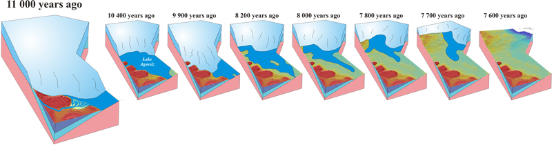
What happened to all that mud? Download a poster to discover the impact of Lake Agassiz on Manitoba: Glaciers retreat – the last to leave – 11 000 to 7 000 years ago ![]()
The Last 7 000 Years
In the post-glacial period, large amounts of sand and gravel remained in the deposits left behind by retreating glacial ice. Scattered throughout Manitoba, one advantage of these deposits is that it is easily accessible and reduces costs to transport the sand and gravel to construction sites or elsewhere that it may be used. In addition to providing Manitoba with rich farmland, the clay left behind from glacial Lake Agassiz is a major component in the manufacturing of Portland cement. The clay is also used in producing lightweight aggregate.
What happened after the glaciers finally left? Download a poster to discover how Manitoba's big lakes moved south: Glacial leftovers – post-glacial period – the last 7 000 years ![]()
Explore for more...
Fossils, Rocks, and Time (USGS)
Igneous, metamorphic and sedimentary rocks