![]() Geoscience
Geoscience
Geological Survey Activity TrackerNorthern Manitoba
Geological mapping and compilation at Southern Indian LakeProject Status: Completed (2019)
|
 Project Information
Principal investigator:
Tania Martins
Partnered with:
--
Location:
Southern Indian Lake, NTS 64G
Project Description
Main objectives:
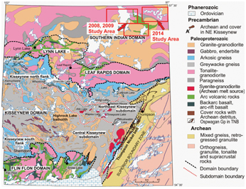
Work completed in 2008 and 2009 was focused the characterization of supracrustal rocks at Southern Indian lake (Pukatawakan Bay and Partridge Breast belts). Preliminary results of this work were published in the report of activities and as preliminary maps (see completed outputs below) but were not published in final format.
This project aims to expand the mapping at Southern Indian lake (this time focusing in the voluminous plutonic rocks) and release all the data in a Geological report.
Methodology:
- Bibliographic search and compilation of previous work
- 1:50 000 scale lithological mapping
- Sample collection for whole rock lithogeochemistry, assay, isotopic and geochronological studies
- Assess potential for base and precious metals, rare metals, and diamonds
Benefits:
This project is intended to synthesize and expand on the work completed in previous years, and thus contribute to the knowledge and understanding of the Southern Indian domain in general, as well as its boundary with the Chipewyan batholith. The results from this project will have implications for the tectonostratigraphic interpretation of the Trans Hudson Orogen, as well as implications for mineral potential.
With this project we aim to stimulate mineral exploration in this region since this area is thought to have potential for base and precious metals, rare metals, and possibly diamonds.
Completed outputs:
2019-2020
Martins, T., Corrigan D. and Rayner, N. 2019: Lithogeochemical, assay and U-Pb geochronological data for the Southern Indian domain, north-central Manitoba (parts of NTS 64G1, 2, 7–10, 64H3–6); Manitoba Growth, Enterprise and Trade, Manitoba Geological Survey, Data Repository Item DRI2019001, Microsoft® Excel® file.
Martins, T., Kremer, P.D., Corrigan, D. and Rayner, N. 2019: Geology of the Southern Indian Lake area, north-central Manitoba (parts of NTS 64G1, 2, 7–10, 64H3–6); Manitoba Growth, Enterprise and Trade, Manitoba Geological Survey, Geoscientific Report GR2019-1, 51 p. and 4 colour maps at 1:50 000 scale.
2016-2017
Martins, T. 2016: Bedrock geology of central Southern Indian Lake, Manitoba (parts of NTS 64G1, 2, 7, 8); Manitoba Growth, Enterprise and Trade, Manitoba Geological Survey, Preliminary Map PMAP2016-6, scale 1:50 000.
Martins, T. 2016: Geological investigations at central Southern Indian Lake, north-central Manitoba (parts of NTS 64G1, 2, 7, 8); in Report of Activities 2016, Manitoba Growth, Enterprise and Trade, Manitoba Geological Survey, p. 126–134.
Martins, T. 2016: Geological Investigations at Southern Indian Lake, Manitoba: Implications for Mineral Exploration; Manitoba Growth, Enterprise and Trade, Manitoba Geological Survey, Manitoba Mining and Minerals Convention 2016, Winnipeg, Manitoba, November 16–18, 2016, poster presentation.
Martins, T. and Hodder, T. 2016: Bedrock and Surficial Geology Investigations at Southern Indian Lake: Implications for Exploration; Manitoba Growth, Enterprise and Trade, Manitoba Geological Survey, Manitoba Mining and Minerals Convention 2016, Winnipeg, Manitoba, November 16–18, 2016, oral presentation.
Martins T. and McFarlane C.R.M. 2016: Evidence of juvenile-arc magmatism at Northern Indian Lake: implications for base-metal exploration in north-central Manitoba (parts of NTS 64H3, 5, 6); in Report of Activities 2016, Manitoba Growth, Enterprise and Trade, Manitoba Geological Survey, p. 135–141.
Martins, T. and McFarlane, C.R.M. 2016: U-Pb data for the Northern Indian Lake pluton, north-central Manitoba (parts of NTS 64H3, 5, 6); Manitoba Growth, Enterprise and Trade, Manitoba Geological Survey, Data Repository Item DRI2016006, Microsoft® Excel® file.
2015-2016
Martins, T. 2015: Geological mapping in the northern basin of Southern Indian Lake, north-central Manitoba (parts of NTS 64G7, 8, 9, 10); in Report of Activities 2015, Manitoba Mineral Resources, Manitoba Geological Survey, p. 79–88.
Martins, T. 2015: Bedrock geology of the northern basin of Southern Indian Lake, north-central Manitoba (parts of NTS 64G7, 8, 9, 10); Manitoba Mineral Resources, Manitoba Geological Survey, Preliminary Map PMAP2015-4, scale 1:50 000.
Martins, T and Hodder, T.J. 2015: Geological Investigations at Southern Indian Lake, Manitoba: Implications for Mineral Exploration; Manitoba Mineral Resources, Manitoba Geological Survey, Manitoba Mining and Minerals Convention 2015, Winnipeg, Manitoba, November 18–20, 2015, poster presentation.
Martins, T and Hodder, T.J. 2015: Integrated Bedrock and Surficial Mapping at Southern Indian Lake: Pegmatite-hosted Gold and Implications for Exploration; Manitoba Mineral Resources, Manitoba Geological Survey, Manitoba Mining and Minerals Convention 2015, Winnipeg, Manitoba, November 18–20, 2015, oral presentation.
2009-2010
Kremer, P.D., Rayner, N. and Corkery, M.T. 2009: New results from geological mapping in the west-central and northeastern portions of Southern Indian Lake, Manitoba (parts of NTS 64G1, 2, 8, 64H4, 5); in Report of Activities 2009, Manitoba Innovation, Energy and Mines, Manitoba Geological Survey, p. 94–107.
Kremer, P.D., Corkery, M.T. and Lenton, P.G. 2009: Bedrock geology of the Partridge Breast Lake belt, Manitoba (parts of NTS 64G1, 8, 64H4, 5); Manitoba Innovation, Energy and Mines, Manitoba Geological Survey, Preliminary Map PMAP2009-2, scale 1:50 000.
Kremer, P.D., Rayner, N. and Corkery, M. T. 2009: Geology, geochemistry and geochronology of Southern Indian Lake, Northern Manitoba; Manitoba Innovation, Energy and Mines, Manitoba Geological Survey, Manitoba Mining and Minerals Convention 2009, Winnipeg, Manitoba, November 19–21, 2009, oral presentation.
Kremer, P.D., Rayner, N. and Corkery, M.T. 2009: Geology, geochemistry and geochronology of the Southern Indian Lake Area, Northern Manitoba; Manitoba Innovation, Energy and Mines, Manitoba Geological Survey, Manitoba Mining and Minerals Convention 2009, Winnipeg, Manitoba, November 19–21, 2009, poster presentation.
2008-2009
Kremer, P.D. 2008: Geological investigations of the Pukatawakan Bay belt, Southern Indian Lake, Manitoba (part of NTS 64G2); in Report of Activities 2008, Manitoba Science, Technology, Energy and Mines, Manitoba Geological Survey, p. 87–98.
Kremer, P. D. 2008: Bedrock geology of the Pukatawakan Bay area, Southern Indian Lake, Manitoba (part of NTS 64G2); Manitoba Science, Technology, Energy, and Mines, Manitoba Geological Survey, Preliminary Map PMAP2008-3, scale 1:25 000.
Kremer, P. D. 2008: Preliminary results from geological mapping in Pukatawakan Bay, northern Manitoba (part of NTS 64G2); Manitoba Science, Technology, Energy and Mines, Manitoba Geological Survey, Manitoba Mining and Minerals Convention 2008, Winnipeg, Manitoba, November 20–22, 2008, poster presentation.


