![]() Geoscience
Geoscience
Geological Survey Activity TrackerNorthern Manitoba
Far North Geomapping Initiative: Northwest Manitoba
|
 Project Information
Principal investigators:
Christian Böhm, Michelle Gauthier, Chris Couëslan
Partnered with:
Geological Survey of Canada (GSC)
Location:
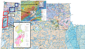
Northwestern Manitoba: Misty Lake, Snyder Lake
Project Description
Main objectives:
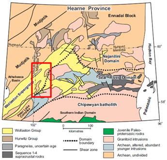
This project will examine and characterize the plutonic and supracrustal rocks which occur on the southern Hearne craton margin in NW Manitoba. The collected data will be integrated with other components of the Far North Geomapping Initiative (Nejanilini, Kasmere-Putahow lakes areas) to provide a comprehensive and modern geoscientific database to assist in mineral exploration in this remote corner of the province.
Methodology:
- 1:50,000 scale lithological and structural bedrock mapping
- Geochemical, geochronological and isotopic analyses of supracrustal and plutonic rocks
- Assessment of lithostratigraphic framework, tectonic evolution, and related mineral potential of the various sequences
- Terrain studies and surficial geological surveys including surficial sediment geochemical analysis as aid for mineral exploration
 Benefits:
In addition to improving existing tectonostratigraphic models for Manitoba’s far north, the resulting suite of geoscientific data can be used to better highlight and assess areas of geological interest with respect to a variety of mineral deposit types and encourage mineral exploration investment in the region.
Status:
- This project was placed on indefinite hold as of June 2019.
Completed outputs:
2011-2012
Kremer, P.D., Böhm, C.O. and Rayner, N. 2011: Far North Geomapping Initiative: bedrock geology of the Snyder Lake area, northwestern Manitoba (part of NTS 64N5); in Report of Activities 2011, Manitoba Innovation, Energy and Mines, Manitoba Geological Survey, p. 6–17.
Kremer, P.D. and Böhm, C.O. 2011: Bedrock geology of the Snyder Lake area, northwestern Manitoba (part of NTS 64N5), Manitoba Innovation, Energy and Mines, Manitoba Geological Survey, Preliminary Map PMAP2011-1, scale 1:35 000.
Rayner, N. 2011: Far North Geomapping Initiative: new U-Pb geochronological results from the Misty Lake area, northwestern Manitoba (part of NTS 64K12, 13); Manitoba Innovation, Energy and Mines, Manitoba Geological Survey, Data Repository Item DRI2011008, Microsoft® Excel® file.
Böhm, C., Kremer, P.D., and Rayner, N. 2011: Bedrock geology and mineral potential of Manitoba’s far northwest; Manitoba Innovation, Energy and Mines, Manitoba Geological Survey, Manitoba Mining and Minerals Convention 2011, Winnipeg, Manitoba, November 17–19, 2011, oral presentation.
Kremer, P.D., Böhm, C. and Rayner, N. 2011: Far North Geomapping Initiative: bedrock geology of Manitoba’s far northwest, with emphasis on uranium and rare-earth element mineralization in the Wollaston domain; Manitoba Innovation, Energy and Mines, Manitoba Geological Survey, Manitoba Mining and Minerals Convention 2011, Winnipeg, Manitoba, November 17–19, 2011, poster presentation.
Trommelen, M.S. 2011: Far North Geomapping Initiative: Quaternary geology of the Snyder–Grevstad lakes area, far northwestern Manitoba (parts of NTS 64N5); in Report of Activities 2011, Manitoba Innovation, Energy and Mines, Manitoba Geological Survey, p. 18–28.
Trommelen, M.S. 2011: Field-based ice-flow indicator data, Synder–Grevstad lakes area, northwestern Manitoba (parts of NTS 64N5); Manitoba Innovation, Energy and Mines, Manitoba Geological Survey, Data Repository Item DRI2011002, Microsoft® Excel® file.
Trommelen, M.S. 2011: Surficial geology, Snyder Lake, northwestern Manitoba (parts of NTS 64N5); Manitoba Innovation, Energy and Mines, Manitoba Geological Survey, Preliminary Map PMAP2011-4, scale 1:50 000.
Trommelen, M.S., Campbell, J.C. 2011: Quaternary geology update for northernmost Manitoba [abstract]; Manitoba Innovation, Energy and Mines, Manitoba Mining and Minerals Convention 2011, November 17–19, 2011, Program, p. 58.
Trommelen, M.S., Campbell, J.E., Kremer, P.D. and Böhm, C.O. 2013: Till composition and ice-flow indicator data, Snyder Lake area, northwestern Manitoba (parts of NTS 64N5); Manitoba Innovation, Energy and Mines, Manitoba Geological Survey, Geoscientific Paper GP2013-1, 20 p.
2010-2011
Kremer, P.D., Carlson, A.R. and Couëslan, C.G. 2010: Geology of the Misty Lake area, Manitoba (parts of NTS 64K12, 13, 64N4); Manitoba Innovation, Energy and Mines, Manitoba Geological Survey, Preliminary Map PMAP2010-2, scale 1:75 000.
Kremer, P.D., Carlson, A.R. and Couëslan, C.G. 2010: Far North Geomapping Initiative: geological mapping of the Misty Lake area, Manitoba (parts of NTS 64K12, 13, 64N4); in Report of Activities 2010, Manitoba Innovation, Energy and Mines, Manitoba Geological Survey, p. 50-61.
Kremer, P.D., Couëslan, C.G., Carlson, A.R. and Rayner, N. 2010: Far North Geomapping Initiative: preliminary results from geological mapping in the Misty Lake area, northwestern Manitoba; Manitoba Innovation, Energy and Mines, Manitoba Geological Survey, Manitoba Mining and Minerals Convention 2010, Winnipeg, Manitoba, November 18–20, 2010, oral presentation.
Kremer, P.D., Couëslan, C.G., Carlson, A.R. and Rayner, N. 2010: Far North Geomapping Initiative: preliminary results from geological mapping in the Misty Lake area, northwestern Manitoba; Manitoba Innovation, Energy and Mines, Manitoba Geological Survey, Manitoba Mining and Minerals Convention 2010, Winnipeg, Manitoba, November 18–20, 2010, poster presentation.


