![]() Geoscience
Geoscience
Geological Survey Activity TrackerNorthern Superior Province
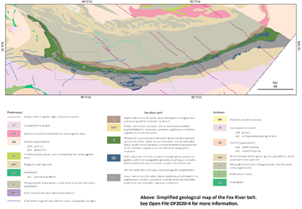
Geological compilation of the Fox River belt Project Status: Completed
(2020)
|
 Project Information
Principal investigators:
Marc Rinne
Partnered with:
--
Location:
NTS 54B, D, 53M, N, O
Project Description
Main objectives:
The aims of this compilation were to:
- Produce a revised geological map of the Fox River Belt (FRB), including major domain boundaries;
- Provide an updated emplacement history and stratigraphic summary of the FRB;
- Investigate broad relationships between the FRB and other rock suites, particularly the Thompson Nickel Belt; and
- Inform exploration targeting Ni-Cu-PGE(±Cr) and Cu-Zn-Pb(±Au,Ag) resources in the Superior Boundary Zone.
Methodology:
Many sources of data were compiled to produce an up-to-date map and genetic model for the Fox River belt. Geological boundaries were updated on the basis of all available data, including airborne magnetic surveys and various drillcore data. Geochemical data were applied to constrain the tectonic setting and stratigraphic evolution of the belt, and to investigate genetic relationships with the Thompson nickel belt.
Benefits:
A new geological compilation of the Fox River belt—including an up-to-date geological map, genetic model, and an assessment of relationships with the Thompson nickel belt—may inform future mineral exploration in the region. This compilation may be used to inform land use planning of the Keewatin Tribal Council and associated communities.
Completed outputs:
2019–2020
Rinne, M.L. 2020: Bedrock geology of the Fox River belt, Manitoba (parts of NTS 53M–O, 54B, D); Manitoba Natural Resources and Northern Development, Manitoba Geological Survey, Open File OF2020-4, 1 map at 1:250 000 scale, 2 maps at 1:525 000 scale and 1 map at 1:50 000 scale.
2018–2019
Rinne, M.L., 2018: Summary of key results and interpretations from the Fox River belt compilation project, northeastern Manitoba (parts of NTS 53M, N, O, 54B, C, D); in Report of Activities 2018, Manitoba Growth, Enterprise and Trade, Manitoba Geological Survey, p. 25–36.
2017–2018
Hodder, T.J., Kelley, S.E., Trommelen, M.S., Ross, M. and Rinne, M.L. 2017: The Kaskattama highland: till composition and indications of a new Precambrian inlier in the Hudson Bay Lowland?; Geological Association of Canada–Mineralogical Association of Canada, Joint Annual Meeting, Kingston, Ontario, May 14–17, 2017, poster presentation.
Hodder, T.J., Kelley, S.E., Trommelen, M.S., Ross, M. and Rinne, M.L. 2017: The Kaskattama highland: till composition and indications of a new Precambrian inlier in the Hudson Bay Lowland?; Manitoba Growth, Enterprise and Trade, Manitoba Geological Survey, Manitoba Mining and Minerals Convention 2017, Winnipeg, Manitoba, November 15–16, 2017, poster presentation.
Rinne, M.L. 2017: Geological compilation of the Fox River belt, Manitoba; Manitoba Growth, Enterprise and Trade, Manitoba Geological Survey, Manitoba Mining and Minerals Convention 2017, Winnipeg, Manitoba, November 15–16, 2017, poster presentation.
2016–2017
Rinne, M.L. 2016: Geological compilation of the Fox River belt, Manitoba; Manitoba Growth, Enterprise and Trade, Manitoba Geological Survey, Manitoba Mining and Minerals Convention 2016, Winnipeg, Manitoba, November 16–18, 2016, poster presentation.


