
Geoscience
3-D Geological Mapping in Manitoba: Moving Forward
Sections:
 Abstract
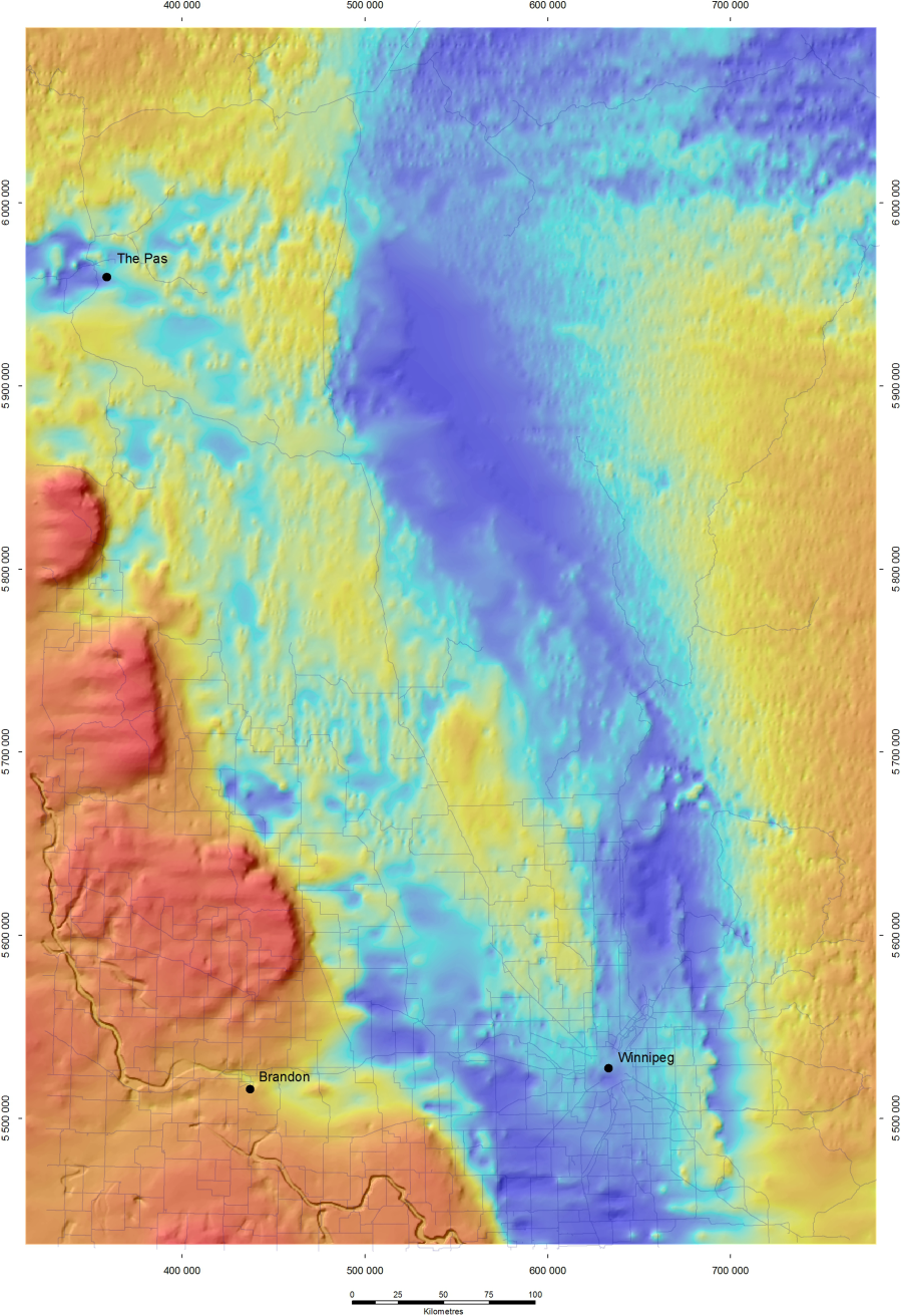
Location Map
Model Outputs
Model Construction: Southern Manitoba
Model Construction: Legend
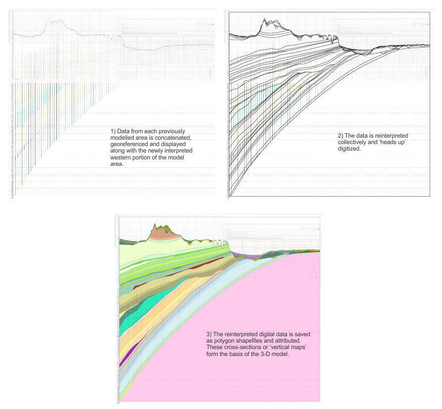
Model Construction: Vertical Maps
Model Construction: 3-D Modelling
Selected Products
References
Archive
Abstract
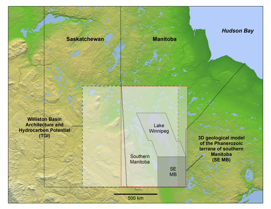
Increasing demand for groundwater and hydrocarbons have been the two main drivers for 3-D modeling in Manitoba. In order to satisfy these demands, and to broaden our knowledge of the subsurface geological and hydrogeological systems, the Manitoba Geological Survey has been moving toward the completion of a three-dimensional (3-D) geological model of the Phanerozoic succession in southern Manitoba, south of latitude 55°N.
Key model inputs are: digital elevation data, bathymetric charts for large lakes, offshore seismic surveys, surficial geological maps, drillhole and seismic data, existing models for the Phanerozoic rock units (the Stratigraphic Map series), and drillhole data. For the Quaternary, critical inputs to the 3-D model are cored holes logged by geologists and geophysical surveys. These high-quality drillholes are extrapolated laterally using data from provincial drillhole databases that include data over 100,000 sites.
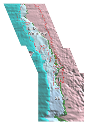
After years of data compilation, two small scale and two regional bedrock models have been completed; 1) the pilot area in southeastern Manitoba (SE MB) which comprises the 200 km x 240 km Winnipeg region, 2) the Lake Winnipeg basin region (Lake Winnipeg), 3) the Targeted Geoscience Initiative Williston Basin Architecture and Hydrocarbon Potential Project's Williston Basin 3D Geological Model (TGI) and 4) the Canadian portion of the Williston Basin derived from the Western Canada Sedimentary Basin Atlas (WCSB). Currently, the MGS is working to complete our modelling in southern Manitoba’s Phanerozoic terrane south of latitude 55°N (Southern Manitoba). This page outlines our 3-D modelling progress and highlights our new bedrock surface; a derivative product of the 3D modelling process.
Location Map
Click image below to enlarge
Model Outputs
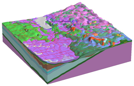
Southeast Manitoba model
Southeast Manitoba (SE MB) modelled bedrock units. (Click image to enlarge) |
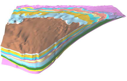
TGI - Williston Basin model
TGI Williston Basin model depicting bedrock units from Devonian (brown) to Precambrian (pink). The bedrock portion of southern Manitoba is based upon this model. (Click image to enlarge)
|
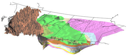
WCSB model
WCSB model depicting major geological time periods from the Tertiary (light green) to Precambrian (pink). Brown represents deformed Cordilleran rocks. (Click image to enlarge) |
Lake Winnipeg model
Southeast Manitoba (SE MB) and Lake Winnipeg bedrock surface displaying the new Paleozoic edge within the Lake Winnipeg basin. (Click image to enlarge) |
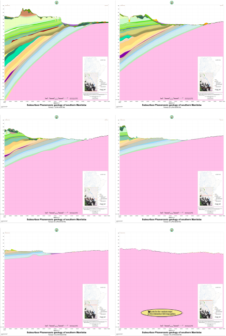
Model Construction: Southern Manitoba
Click image above to enlarge
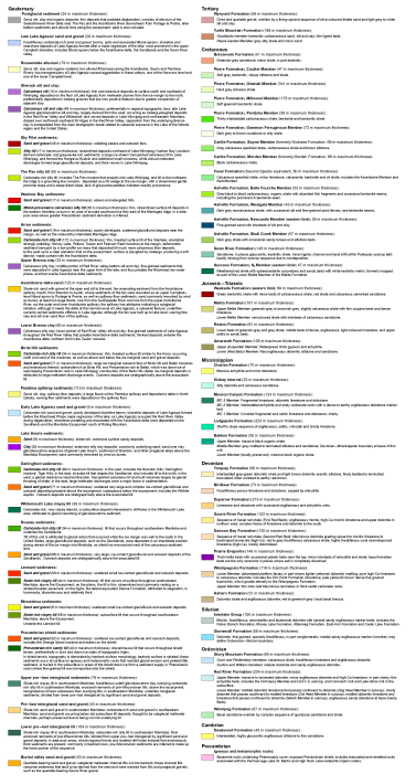
Model Construction: LegendClick image below to enlarge
|
Model Construction: Vertical MapsClick image below to enlarge |
The complete set of 134 ‘Vertical Maps’ used for modelling was released as part of the Stratigraphic Map Series (SM2012-1) and are available for viewing and/or download. |
|
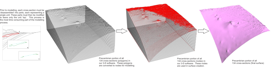
Model Construction: 3-D Modelling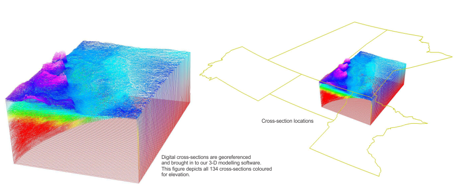
Click image above to enlarge
The Precambrian surface is the ‘simplest’ surface to create. It has no unit edge and can be modelled directly from the nodes.
Click image above to enlarge
Most units have a defined unit ‘edge’, or subsurface extent. Many units also have subsurface channels. These units are more complex to model. The 3-D model cross-sections require existing unit edges to be modified in order to fit the data. The example unit below is the Cretaceous Pierre Formation, Odanah Member.
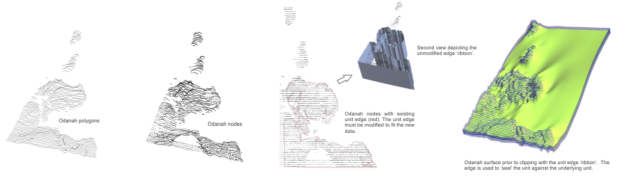
Click image above to enlarge
Click here to view a 2-D representation (stacked polygons) of the original data (unit edges) that provided the foundation for the construction of the 3-D model.
Selected Products
Bedrock Topography of Southern Manitoba
The bedrock surface includes buried valley aquifer (BVA) channel data. BVA data is combined with the digital elevation model as well as channel outlines from the modelled cross- sections. The suspected channels are then digitized and then compared with the modelled data in 3D. These digitized lines are then incorporated and modelled.
Click images below to enlarge
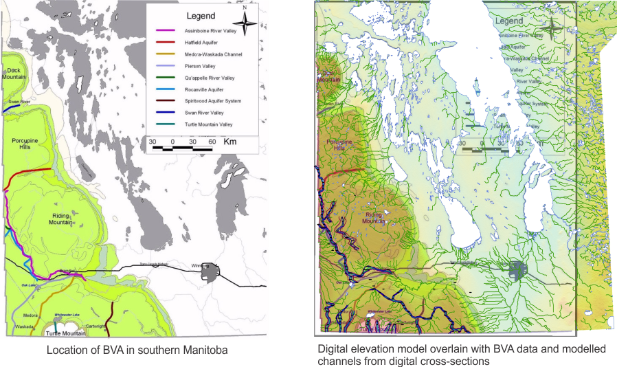
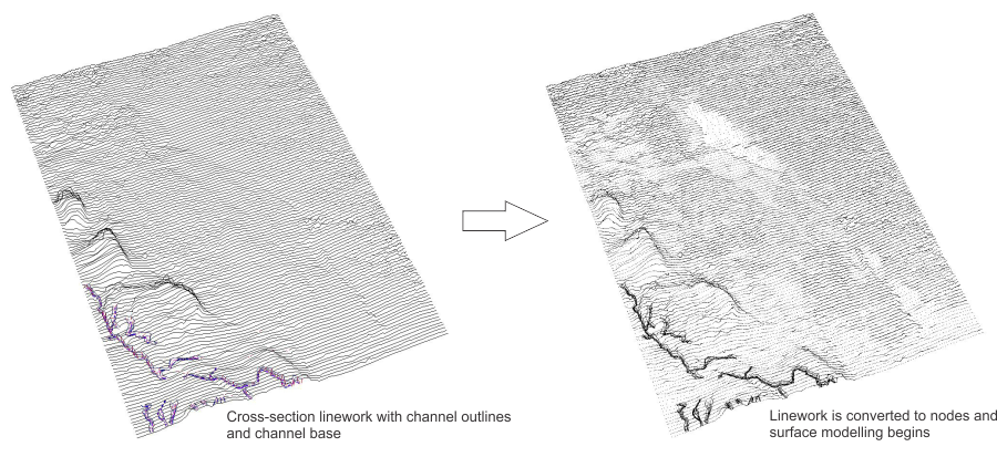
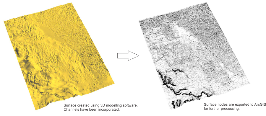
Final image below depicts bedrock surface with incorporated BVA channels:
BVA channel figures from:
Hinton, M.J., Pugin, A.J-M., Pullan, S.E., Betcher, R.N. 2007: Insights into the Medora-Waskada
buried valley aquifer from geophysical surveys, southwestern Manitoba; Canadian Geotechnical
Society-International Association of Hydrogeologists, 60th Canadian Geotechnical Conference
and the 8th Joint CGS/IAH-CNC Groundwater Conference, OttawaGeo 2007, Ottawa, ON,
October 21-24, 2007, Proceedings, p. 515-522.
Geoscientific Map MAP2021-1
Bedrock topography of southern Manitoba
By G.R Keller and G.L.D Matile
Archive
Click here to view a 2-D representation (stacked polygons) of the original data (unit edges) that provided the foundation for the construction of the 3-D model.