
Geoscience
Surficial Geology
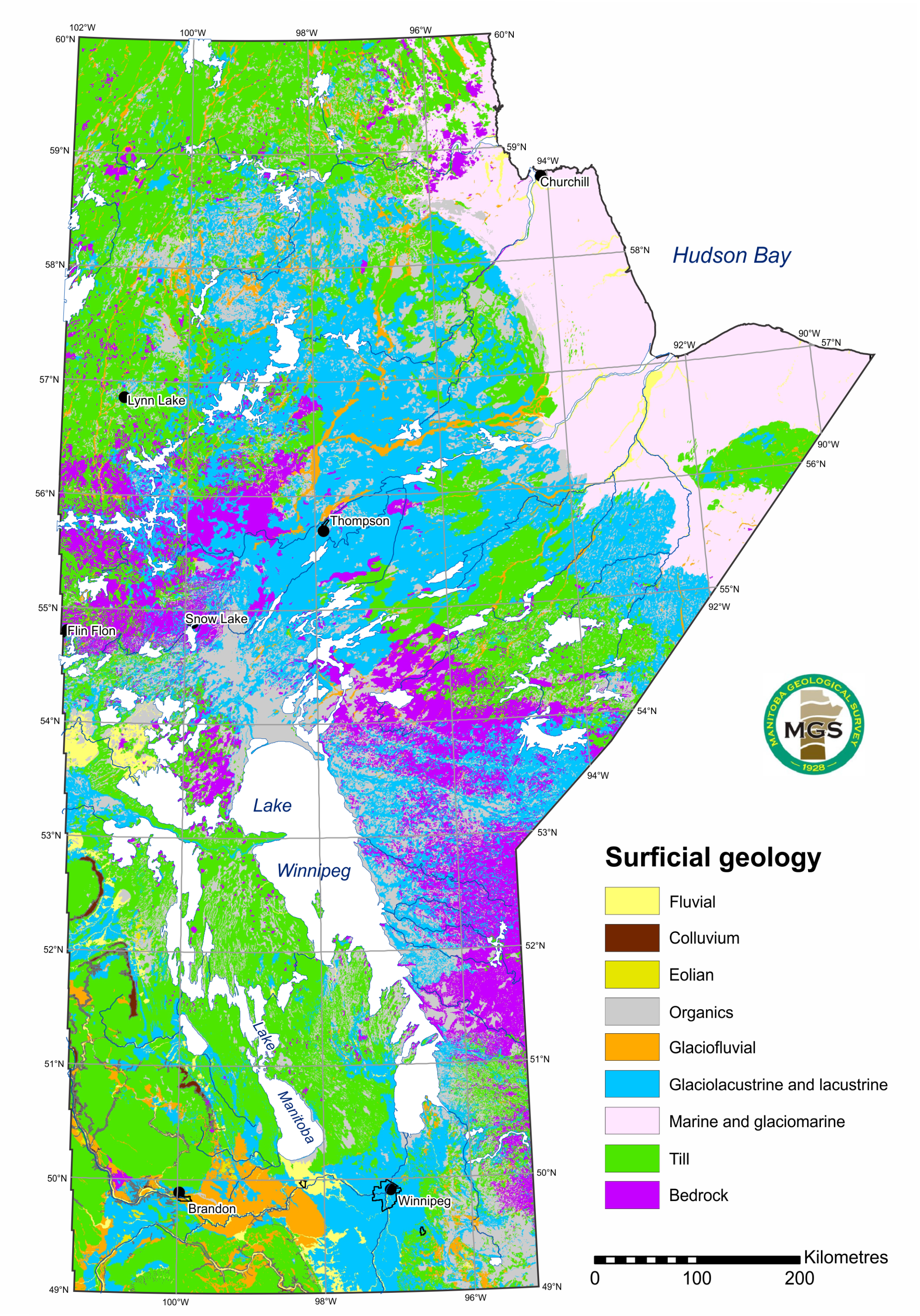
Surficial geology focuses on the description of the types and distributions of unconsolidated sediments across the landscape. Surficial-geological data is essential for the successful interpretation of ice flow and glacial history in Manitoba. This information is collected and maintained primarily in maps and databases. It is useful for mineral exploration, sand and gravel production, hazard assessment, and infrastructure and landuse planning.
Applications of Surficial geology data (PDF)
2023–2024 releases
Compilations
Gauthier, M.S. 2023: Manitoba till-matrix geochemistry compilation: visible gold grains in the heavy mineral (<2 mm) size-fraction; Manitoba Economic Development, Investment, Trade and Natural Resources, Manitoba Geological Survey, GeoFile 8-2023, Microsoft® Excel® file.
Gauthier, M.S. 2023: Manitoba till-matrix geochemistry compilation: total carbonate of the silt plus clay (<63 μm) size-fraction; Manitoba Economic Development, Investment, Trade and Natural Resources, Manitoba Geological Survey, GeoFile 7-2023, Microsoft® Excel® file.
Gauthier, M.S. 2023: Manitoba radiocarbon ages; Manitoba Economic Development, Investment and Trade, Manitoba Geological Survey, GeoFile 6-2023.
Scientific papers
Hodder, T.J., Gauthier, M.S., Ross, M. and Lian, O.B. 2023: Was there a nonglacial episode in the western Hudson Bay Lowland during Marine Isotope Stage 3?; Quaternary Research, v. 116, p. 148–161.
Dalton, A.S., Dulfer, H.E., Margold, M., Heyman, J., Clague, J.J., Froese, D.G., Gauthier, M.S., Hughes, A.L.C., Jennings, C.E., Norris, S.L. and Stoker, B.J. 2023: Deglaciation of the north American ice sheet complex in calendar years based on a comprehensive database of chronological data: NADI-1; Quaternary Science Reviews, v. 321, art. 108345.
Data
Hodder, T.J. and Gauthier, M.S. 2023: Indicator mineral and gold grain data from till sampled in the Churchill to Little Churchill rivers area, northeastern Manitoba; Manitoba Economic Development, Investment and Trade, Manitoba Geological Survey, Open File OF2023-1, 19 p., 4 appendices.
Gauthier, M.S. and Hodder, T.J. 2023: Quaternary site data, till composition and ice-flow indicators in the Roseau River area, southeastern Manitoba (parts of NTS 62H2, 7); Manitoba Economic Development, Investment, Trade and Natural Resources, Manitoba Geological Survey, Open File OF2023-3, 10 p., 8 appendices.
Matile, G.L.D., Thorleifson H. and Gauthier, M.S. 2023: Rotosonic borehole stratigraphy, southeastern Manitoba (parts of NTS 52E, 62H); Manitoba Economic Development, Investment and Trade, Manitoba Geological Survey, Data Repository Item DRI2023005, Microsoft® Excel® file, photos and PDFs.
Matile, G.L.D., Thorleifson, L.H., Martin, A.B. and Hodder, T.J. 2023: Quaternary field site data collected during the 1997–1998 NATMAP field seasons, southeastern Manitoba (parts of NTS 52L, 62H, I); Manitoba Economic Development, Investment, Trade and Natural Resources, Manitoba Geological Survey, Data Repository Item DRI2023010, Microsoft® Excel® file.
Matile, G.L.D., Thorleifson, L.H., Martin, A.B. and Hodder, T.J. 2023: Quaternary field site data collected during the 1993–1994 NATMAP field seasons, southeastern Manitoba (parts of NTS 52E, 62A, H); Manitoba Economic Development, Investment, Trade and Natural Resources, Manitoba Geological Survey, Data Repository Item DRI2023009, Microsoft® Excel® file.
Hodder, T.J. 2023: Sediment gold grain count data from the Little Bear Lake property (AFN 74096), southeastern Manitoba; Manitoba Economic Development, Investment and Trade, Manitoba Geological Survey, Data Repository Item DRI2023001, Microsoft® Excel® file.
Hodder, T.J. 2023: Gold and indicator-mineral data derived from glacial sediments (till) in southeastern Manitoba (parts of NTS 52L, 62P, 63A): 2022 pilot study results; Manitoba Economic Development, Investment, Trade and Natural Resources, Manitoba Geological Survey, Data Repository Item DRI2023011, Microsoft® Excel® file.
Hodder, T.J. and Gauthier, M.S. 2023: Field-based ice-flow–indicator data collected during 2023 field season in southeastern Manitoba (parts of NTS 52L, M); Manitoba Economic Development, Investment, Trade and Natural Resources, Manitoba Geological Survey, Data Repository Item DRI2023012, Microsoft® Excel® file.
Gauthier, M.S. and Hodder, T.J. 2023: Till geochemistry and heavy mineral analyses (gold, MMSIM®, visual KIM) of the western Fox River greenstone belt area, northeastern Manitoba (NTS 53M15, 16, parts of 53N13, 54C4, 54D1): year 2; Manitoba Economic Development, Investment, Trade and Natural Resources, Manitoba Geological Survey, Data Repository Item DRI2023015, Microsoft® Excel® file.
Gauthier, M.S. and Hodder, T.J. 2023: Till geochemistry and heavy mineral analyses (gold, MMSIM®, visual KIM) from three sections near the confluence of the Hayes and Gods rivers, northeastern Manitoba (part of NTS 54C7); Manitoba Economic Development, Investment, Trade and Natural Resources, Manitoba Geological Survey, Data Repository Item DRI2023008, Microsoft® Excel® file.
Gauthier, M.S. and Hodder, T.J. 2023: Till-matrix geochemistry data from the Gillam area, northeastern Manitoba: additional 2022 data (NTS 54D5–8, 64A2); Manitoba Economic Development, Investment and Trade, Manitoba Geological Survey, Data Repository Item DRI2023004, Microsoft® Excel® file.
Gauthier, M.S. and Godbout, P.-M. 2023: Till-matrix geochemistry re-analyses data from far northeastern and far northwestern Manitoba (parts of NTS 54E, F, L, 64J, K, N, O); Manitoba Economic Development, Investment, Trade and Natural Resources, Manitoba Geological Survey, Data Repository Item DRI2023007, Microsoft® Excel® file.
Report of Activities
Hodder, T.J. and Martins, T. 2023: Current Quaternary geology investigations in southeastern Manitoba and implications for mineral exploration (parts of NTS 52L, 62P, 63A); in Report of Activities 2023, Manitoba Economic Development, Investment, Trade and Natural Resources, Manitoba Geological Survey, p. 105–119.
Mesich, N., Gauthier, M.S., Hodder,
T.J., Hathaway, J., Schaarschmidt,
M., Lian, O.B. and Ross, M. 2023: Quaternary stratigraphic investigations
along the Gods and Yakaw
rivers, northeastern Manitoba
(parts of NTS 54C2, 7); in Report of
Activities 2023, Manitoba Economic
Development, Investment, Trade
and Natural Resources, Manitoba
Geological Survey, p. 120–123.
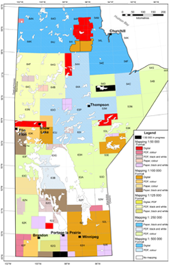
Surficial Geology Map Index Click on the map sheet below for map listings.
|
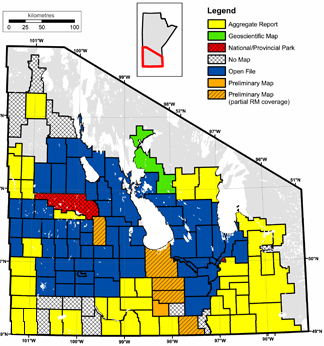
Aggregate Resources Click on the rural municipality map sheet below for more information regarding existing publications.
|
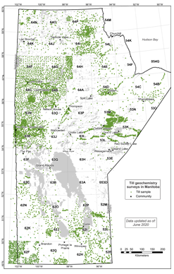
Till Geochemistry Map Index Click on the map sheet below for map listings.
|
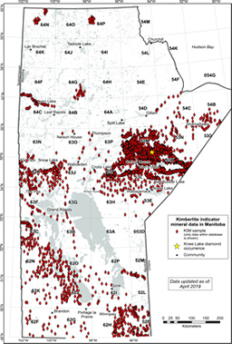
Kimberlite-indicator Minerals Click on the map sheet below for more information.
|
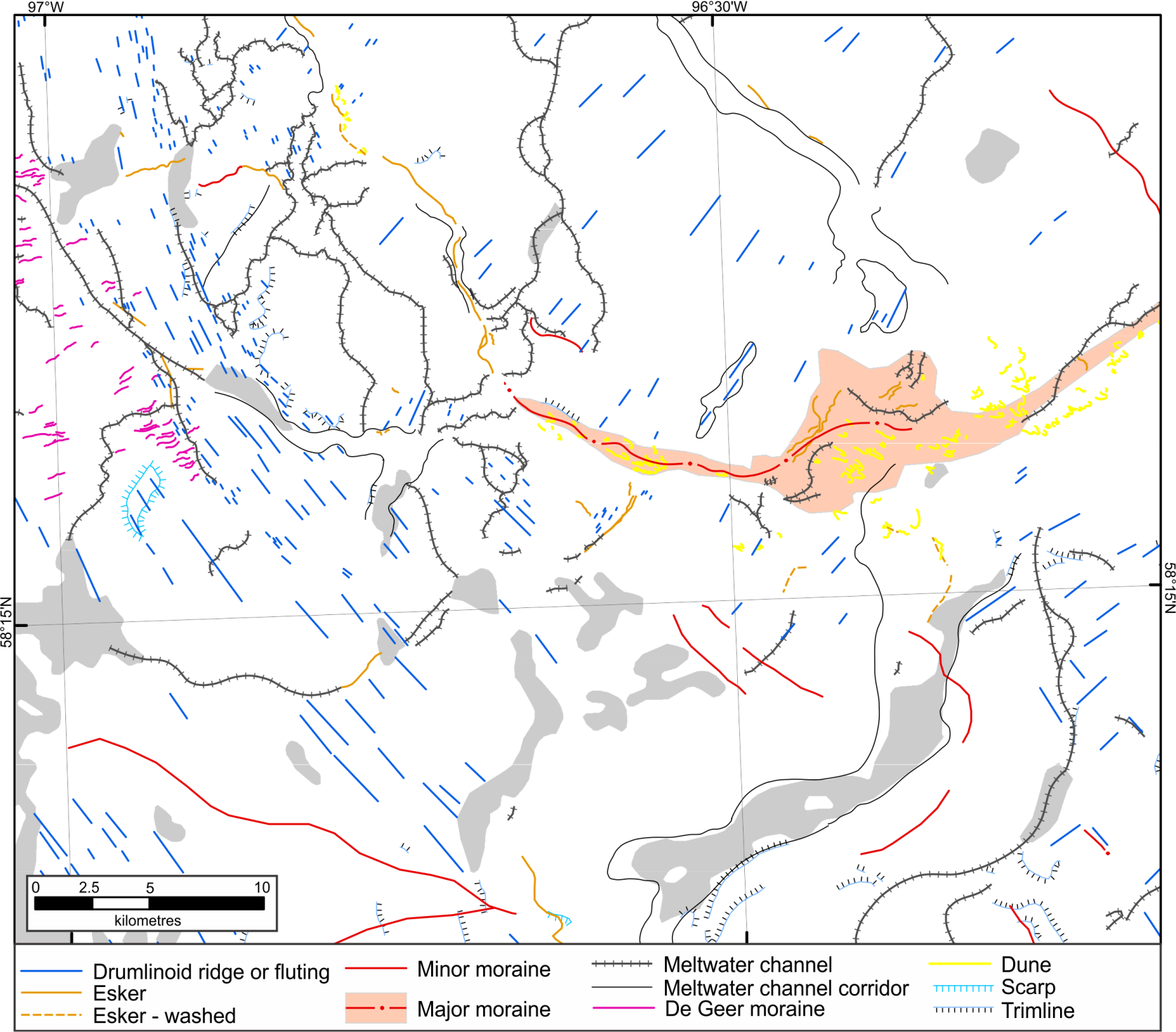
Digital compilation of surficial point and line featuresThese datasets provide an up-to-date digital compilation of historic and new point and line features that are typically present on surficial geology maps, including:
|
 |
Current projects
- Till sampling and Quaternary stratigraphy of the Machichi–Kettle rivers area
- Gillam area (parts of NTS 54D)
- Kasmattama highlands, Hudson Bay Lowland
- Pilot Mound/Morden
- Western Fox River belt, NTS 53M15 and 16
- Ongoing carbonate dispersal analyses
- Omarolluk (Omar) erratics
Completed projects
- Arden (NTS 62J6)
- Gauer Lake to Wishart Lake (NTS 64H)
- Knee Lake–Oxford Lake (NTS 53L)
- Lynn Lake area (parts of NTS 64F3, 4; 64C9, 11, 12, 14, 15, 16; 64B12)
- Northeastern-most Manitoba
- Southern Indian Lake (parts of 64G)
- Updated post-glacial marine limits along western Hudson Bay, central mainland Nunavut and northern Manitoba
To search for or download free publications related to all quaternary and surficial projects in Manitoba, please visit the Bibliography of Manitoba Geology.
Digital capture of potential aggregate depositsThis data capture is part of an ongoing project to compile existing Manitoba Geological Survey aggregate publications and digitally capture the spatial data component in a GIS format. This is intended as an initial release of the data capture, which will be followed by additional data published as an Open File. |
Surficial map compilationsFor more information, visit the Surficial Geology Compilation Map Series web page. How to create a surficial map (PDF)
Cross-sectionsCross-sections maps can be downloaded off of the Phanerozoic Stratigraphy page.
|
 |