
Project Overview
Current Status:
Fall 2024
- On November 19th, 2024, the Manitoba government released its Speech from the Throne to open the Second Session of the 43rd Manitoba Legislature. The speech committed to protecting communities from flooding by moving forward with the Outlet Channels project and resetting relationships with Indigenous Nations. Read the Manitoba government’s 2024 Speech from the Throne here:
- On November 13, 2024, Honourable Lisa Naylor received an updated mandate letter from the Honourable Wab Kinew, Premier of Manitoba, instructing the minister to consult with Indigenous Nations and get to work building the Lake Manitoba and Lake St. Martin Outlet Channels to protect communities from flooding. Read the mandate letter here:
- In 2011, southern Manitoba experienced widespread flooding and Lake Manitoba experienced high inflows through the Waterhen River, Whitemud River, and the Portage Diversion. This project is intended to improve water regulation of Lake Manitoba and Lake St. Martin. The project will also reduce the likelihood of flooding on both Lake Manitoba and Lake St. Martin.
Project Rationale
Why are the Lake Manitoba and Lake St. Martin channels needed?
- Flooding in 2011 and 2014 highlighted the need to better regulate water levels on both lakes.
- The Assiniboine River and Lake Manitoba Basins Flood Mitigation Study (2016) recommended that the Lake Manitoba outlet channel be constructed to accommodate flows of 7,500 cubic feet per second (cfs); and the Lake St. Martin Emergency Outlet Channel be made permanent and enhanced to accommodate flows up to 11,500 cfs.
- The need for these permanent outlet channels was also identified in the recommendations from the 2011 Flood Review Task Force (ZIP, 62 MB), and Lake Manitoba and Lake St. Martin Regulation Review Committee (2013).
 |
 |
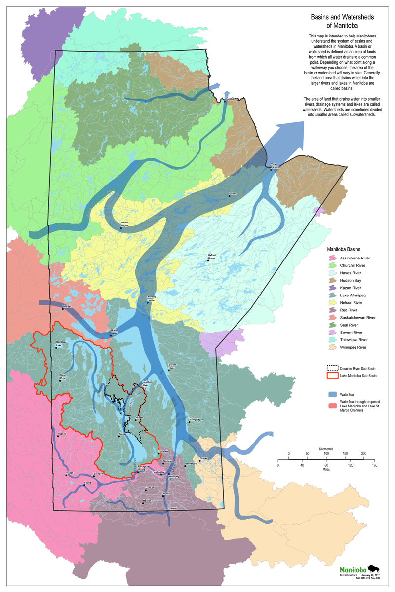
Due to its geographic location and topography, many areas of Manitoba are susceptible to flooding. Water moves from the Rocky Mountains, northern United States and the boreal forest through Manitoba on the way to Hudson Bay. Manitoba’s landscape was largely shaped by glacial processes and as a result, large portions of the province are relatively flat and subject to flooding during high run-off events. While much of Manitoba is vulnerable, Manitobans are generally well protected due to investments in flood protection infrastructure from previous generations.
The outlet channels are being designed to provide enhanced flood protection to communities (Indigenous and non-Indigenous), agricultural producers and recreational users along Lake Manitoba, Lake St. Martin, and the Dauphin River, without appreciably affecting water levels on Lake Winnipeg.
The two outlet channels are components of an integrated flood mitigation network that are intended to work together:
- The Lake Manitoba outlet channel will work in tandem with the existing Fairford River Water Control Structure to help regulate water levels and mitigate flooding on Lake Manitoba.
- The Lake St. Martin outlet channel will provide flood protection by mitigating increased inflows from operation of the Fairford River Water Control Structure, as well as additional inflows from the planned outlet from Lake Manitoba.
- In addition to providing flood protection around Lake Manitoba and Lake St. Martin, the two proposed channels will allow greater flexibility in operating the provincial water control system including the Shellmouth Dam and Reservoir, the Red River Floodway and the Portage Diversion.
Project Design
In December 2012, consultants undertook a comprehensive study on behalf of the Manitoba government to identify and assess options to reduce flood risk for areas along Lake Manitoba and Lake St. Martin.
Phase 1 conceptual review of alternatives and Phase 2 conceptual design for the outlet channels were completed between 2014 and 2016. The consultants’ preliminary design was completed in January 2016.
In 2018, two assignments were awarded for the engineering design and construction oversight of the channels:
- Hatch Ltd. was awarded the Lake Manitoba engineering design and construction oversight contract. The Lake Manitoba channel includes the flood protection channel, water control structure and preliminary design of two bridges. TREK Geotechnical Inc., Stantec Consulting Ltd. and Dillon Consulting Ltd. will assist with this component of the project.
- KGS Group was awarded the Lake St. Martin engineering design and construction oversight contract. The Lake St. Martin channel includes the flood protection channel and water control structure. WSP Global Inc. and North/South Consultants Inc. will assist with this component of the project.
Project Components
The proposed Lake Manitoba and Lake St. Martin outlet channels project consists of three components:
- Lake Manitoba outlet channel with a design capacity of 7,500 cfs (212 cubic metres per second [cms]) at a water level of 814.0 feet (23.1 metres) above sea level (asl)
- Lake St. Martin outlet channel with a design capacity of 11,500 cfs (326 cms) at a water level of 801.0 feet (22.7 metres) asl
- 24 kV distribution line to allow for operation of the control structure of the Lake St. Martin outlet channel
- Project Components Information Sheet (PDF, 1.3 MB)

Map showing the location of the three project components
Lake Manitoba outlet channel
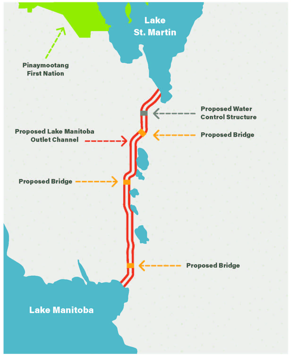
The 7,500 cfs (212 cms) channel will result in a significantly greater ability to maintain Lake Manitoba water levels below the flood stage.
Project details include:
- An approximate 23 km channel connecting Watchorn Bay on Lake Manitoba to Birch Bay on Lake St. Martin
- Situated on privately held land and Crown leased land
- Involves a water control structure and several bridges
These are the estimated project components. The project may be modified as design and construction proceed.
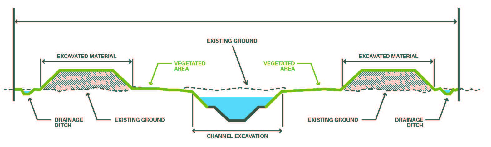
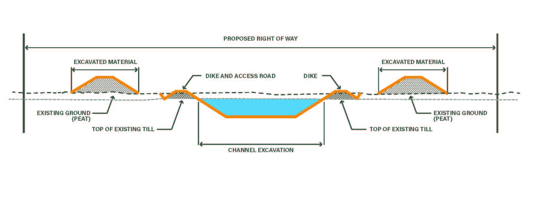
Cross section view of the Lake Manitoba outlet channel
Lake St. Martin outlet channel
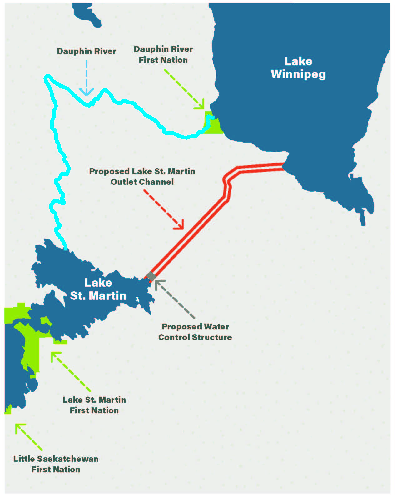
The channel will require relocation of the existing channel inlet and will consist of a new channel so water can drain from Lake St. Martin to Lake Winnipeg. The existing Lake St.Martin Emergency Channel (constructed in 2011) will be repurposed to act as a recharge channel for the wetland complex and provide future environmental benefits.
Project details include:
- Designed at a capacity of 11,500 cfs (326 cms)
- Approximately 23 km in length
- Water control structure and bridge
- Situated on unoccupied Crown land
These are the estimated project components. The project may be modified as design and construction proceed.
Cross section view of the Lake St. Martin outlet channel
Proposed Operation
The Manitoba government will operate the Lake Manitoba and Lake St. Martin outlet channels using an approved set of guidelines. The proposed guidelines are available here:
Operation of the outlet channels will maintain a water level range of 810.5 to 812.5 feet above sea level on Lake Manitoba, and 797 to 800 feet above sea level on Lake St. Martin.
- The Operations Information Sheet (PDF, 2.5 MB)
- Videos