
Historic Floods
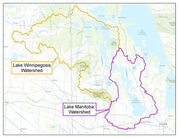
Lake Manitoba, Lake St. Martin and Lake Winnipegosis
Water levels on Manitoba's large lakes are affected by the weather conditions in their drainage basins, as well as the capacity of their outlet channels. Some lakes such as Lake Manitoba and Lake St. Martin have a long history of both high and low lake levels, which vary depending on the inflows.
2011
Flooding on Lake Manitoba
Water levels on Lake Manitoba reached a record-high peak in late July of 2011 at 249.1 metres (817.2 feet) above sea level, more than 1.4 metres (4.7 feet) higher than the top of the desirable range of 810.5 to 812.5 feet. High water levels continued into the late fall, when water remained approximately 0.6 metres (2 feet) above the top of the desirable range. The unprecedented high levels were a result of numerous factors, including:
High water levels on Lake Manitoba in 2010 were due to above average precipitation in the fall of 2010. Outflows out of Lake Manitoba through the Fairford River Water Control Structure were kept at maximum except for three months in the winter when they were reduced to moderate Lake St. Martin water levels which, in turn, moderated flows on that lake's outlet, the Dauphin River. Moderating the river flows minimized the impact of frazil ice development which typically occurs with high flows on the river.
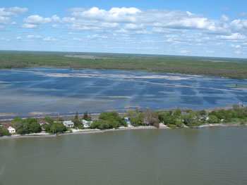 Aerial view of flooding at Lundar Beach, June 1, 2011 |
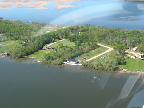
 Aerial view of flooding at Delta Beach, May 17, 2011 |
Record high inflow volume from Lake Winnipegosis in 2011. The total volume of inflow from Lake Winnipegosis into Lake Manitoba in 2011 was the second highest ever recorded, second only to the record inflow volume in 2010.
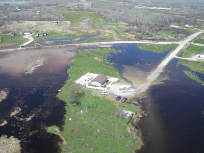
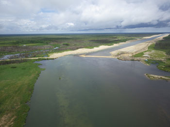
 Aerial view of flooding at the town of Waterhen, June 1, 2011 |
Above average precipitation resulted in significant rainfall over the lake and surrounding watershed. This contributed to the high lake levels. The wind storms also caused real property damage around the lake. In particular, the storm between May 27 and June 1, resulted in waves as high as 2.1 metres (7 feet) hitting dikes and buildings. In addition to significant rainfall, on May 31 gale force winds (40 km/hr and higher) magnified the already destructive wave action, destroying or severely damaging many cottages and homes around Lake Manitoba.
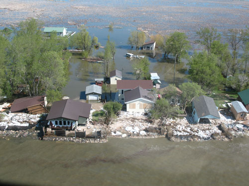
Aerial view of St. Laurent following the storm
event, June 1, 2011
High and prolonged usage of the Portage Diversion. Due to the unprecedented high flows on the Assiniboine River, a large volume of water was diverted from the Assiniboine River into Lake Manitoba via the Portage Diversion. Water was diverted from the Assiniboine River to Lake Manitoba for a period of 126 days. For 31 days the flow was in excess of the Diversion's design capacity of 707.9 cms (25,000 cfs). During operation in 2011, the Portage Diversion diverted a record volume of 4.73 million acre-feet (5.83 million dam3) of water into Lake Manitoba.Levels on Lake Manitoba were lowered due to the following factors:
Positive Influence of the Fairford River Water Control Structure. When the Fairford River Water Control Structure (FRWCS) was built in 1961 the outlet channel was enlarged, increasing the potential outflow capacity out of Lake Manitoba by up to three times the natural outlet capacity. The increased outlet capacity was designed to help maintain more stable levels on Lake Manitoba. It also allowed for higher outflows to offset the additional inflows that would be diverted from the Assiniboine River once the Portage Diversion was put into operation. The increased outlet capacity also allows lake levels to be brought down more quickly when needed. This additional outflow capacity provided a significant flood reduction benefit to Lake Manitoba. For example, in the calendar year 2011, the total outflow volume recorded through the FRWCS was 10,514,000 acre-feet (13,000,000 dam3). The computed natural outflow volume through the Fairford River in the absence of the FRWCS would have been 7,014,000 acre-feet (8,650,000 dam3). Of note, these values only show the benefit that the FRWCS provided during the flood event; they do not include the beneficial reduction in water levels provided before and after the flood event. At the end of 2012, operation of the FRWCS helped bring lake levels down to 248.5 metres (812 feet), about 0.75 metres (2.5 feet) lower than what levels would have occurred in the absence of the FRWCS and Portage Diversion.
Prior to construction of the Fairford River Water Control Structure, Lake Manitoba exceeded the level 247.95 metres (813.5 feet) for four consecutive years, from 1954 to 1957, and it reached a peak of 248.79 metres (816.25 feet) in July of 1955 because of the limited outlet capacity. If the Fairford River Water Control Structure had not been built, lake water levels would have exceeded 247.95 metres (813.5 feet) for about six years in total between 1961 and 2011. However, the increased capacity of the structure kept water levels below 274.8 metres (813 feet) virtually the entire period.
Overflows from the Assiniboine River. The Portage Diversion channel generally follows low-lying land between Portage la Prairie and Lake Manitoba. Reports from the historic 1882 flood indicate that overflows from the Assiniboine River, from this location on the Assiniboine River, travelled north to Lake Manitoba at a depth of 2.13 metres (7 feet), contributing a considerable volume of water to Lake Manitoba. In 2011, flows in the Assiniboine River west of Portage la Prairie exceeded 622.97 cms (22,000 cfs) for 105 days. Under natural conditions, overflows from the Assiniboine River would have occurred during that period and a portion of those overflows would have reached Lake Manitoba and added to the already high natural levels that would have occurred in Lake Manitoba in the absence of all flood control works. Overflows from the Assiniboine River were prevented by a combination of the Assiniboine River dikes and operation of the Portage Diversion to limit flows on the lower Assiniboine River. The 2011 Flood: Technical Review of Lake Manitoba, Lake St. Martin and Assiniboine River Water Levels (2013) (PDF, 8.2 MB) report details historic overflows and expands on the flood conditions experienced in 2011.
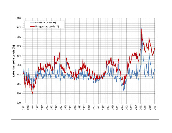
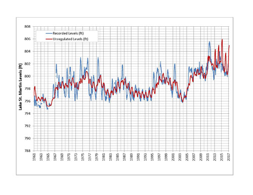
Recorded and unregulated water levels on Lake Manitoba from the start of regulation (1961) to 2017
Flooding on Lake St. Martin
Lake St Martin is susceptible to flooding due to the low-lying landscape surrounding the lake. Wet conditions in 2010 resulted in lake levels reaching a level of 244.1 metres (801 feet) in January 2011, above the historic average of 242.9 to 243.9 metres (797 to 800.5 feet). Lake levels rose above flood stage of 244.4 metres (801.7 feet) in March 2011. Lake St. Martin levels were further increased by record high spring flows on the Fairford River, resulting in a maximum level of 245.5 metres (805.6 feet), approximately 0.6 metres (2 feet) higher than the previous recorded maximum level. Areas around the lake were flooded and community residents were evacuated.
In some past high water events, frazil ice formed on the Dauphin River, the outlet from Lake St. Martin, constricting the channel and significantly reducing the river flow.
Frazil ice is soft or amorphous ice formed by the accumulation of ice crystals in water that is too turbulent to freeze solid.
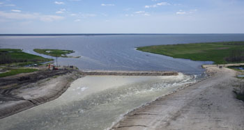
If frazil ice were to develop on the Dauphin River in the fall or winter of 2011 it would have reduced outflow and further exacerbated flooding on Lake St. Martin. If Lake Manitoba outflows through the Fairford River Water Control Structure were reduced to ease the flooding on Lake St. Martin, the water levels on Lake Manitoba would also remain higher for a longer period of time. To address the existing flooding on both lakes and to avert further ice induced flooding over winter, it was determined that an emergency outlet channel was necessary to increase the total outflow from Lake St. Martin. On November 1, 2011, the Manitoba governent opened the Lake St. Martin Emergency Channel, increasing outflow from Lake St. Martin through Big Buffalo Creek. On November 18, water levels on Lake St. Martin had declined to a level of 244.8 metres (803.2 feet), down from the peak of 245.5 metres (805.5 feet).
Read more on the construction and operation of the Lake St. Martin Emergency Outlet Channel
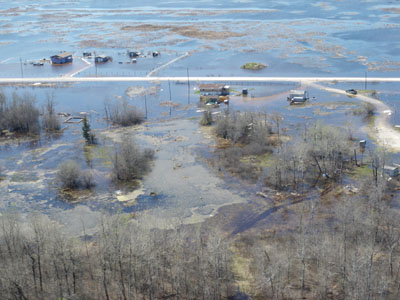
 Lake St. Martin, May 17, 2011 |
|
Lake St. Martin is generally negatively affected by the regulation of Lake Manitoba through operation of the Fairford River Water Control Structure, with Lake St. Martin often suffering artificially high or low water levels depending on conditions on Lake Manitoba. For example, Lake St. Martin now experiences higher inflows (outflows from Lake Manitoba) during high water periods and lower lake levels due to reduced inflow (outflows from Lake Manitoba) during dry periods.
Recorded and unregulated water levels on Lake St. Martin from the start of regulation (1961) to 2017
Flooding on Lake Winnipegosis and the Waterhen River
 Lake Winnipegosis receives inflows from the north slopes of the Riding Mountains, the eastern and northern slopes of the Duck Mountains, the Porcupine Mountains and parts of eastern Saskatchewan. The outlet from Lake Winnipegosis is the Waterhen River, connecting Lake Winnipegosis to the north basin of Lake Manitoba. Lake Winnipegosis outflows are unregulated, so lake levels rise and fall with changing conditions.
The lake level at the start of 2011 was unusually high because of high runoff in the fall of 2010. As a result, the lake reached a peak of 254.5 metres (835 feet) in late June. In 2011 Lake Winnipegosis had the highest summer levels observed since record keeping began in 1913. These high levels resulted in record high flows on the Waterhen River. Approximately 4.7 million acre-feet of water moved from Lake Winnipegosis to Lake Manitoba between April and August. High flows on the Waterhen River continued well into the winter, causing frazil ice on the Waterhen River.
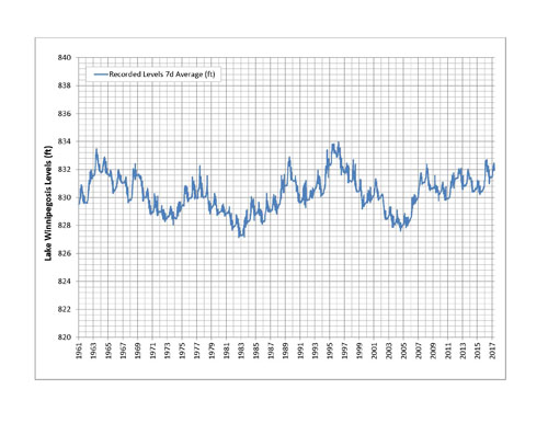
Recorded water levels on Lake Winnipegosis from 1961 to 2017
2014
Manitoba experienced one of the coldest and longest winters on record in 2013/2014, resulting in thicker than usual ice along many rivers and lakes. Spring runoff in 2014 was generally slow to respond and produced moderate to high volumes of flow. The longer period of runoff resulted in above average spring peaks and therefore, water levels on many of Manitoba's lakes and rivers remained high following spring runoff.
April and June were very wet months for most of Manitoba, June in particular brought a lot of precipitation to the Assiniboine, Lake Manitoba and Winnipeg River basins.
The summer flood in southern Manitoba was driven by a large, widespread rain between June 27 and June 30 across western Manitoba and Saskatchewan. Accumulated precipitation in the Souris River basin, Qu'Appelle River, and the Assiniboine River basin ranged from 100 to 200 mm.
The late June storm in Manitoba and Saskatchewan resulted in overland flooding across the Prairies. By the end of June many communities and municipalities in southern and southwestern Manitoba had or were in the process of declaring States of Local Emergencies. Similar actions were also being undertaken in Eastern Saskatchewan.
During the 2014 summer flood, more than 13 rivers and streams in south-western Manitoba and eastern Saskatchewan recorded historic high flows and levels. Examples of historic high flows/levels: Assiniboine River at St. Lazare and Brandon, Qu'Appelle River at Welby, Little Souris River, Birdtail Creek, Medora Creek, Scissor Creek, Pipestone Creek, Silver Creek. Shellmouth Reservoir also saw a record high water level. In the extreme south west corner of the province many bridges and crossings were impacted from river and tributary flooding.
Flooding on Lake Manitoba
Since 2011 the Fairford River Water Control Structure (FRWCS) has generally been operated for maximum possible outflow. A temporary reduction in outflow in the winter is sometimes necessary to minimize the risk of flooding downstream on the Dauphin River due to frazil ice jams. Winter operation requires the installation of stop logs to reduce flow through the structure. In early spring of 2014 the FRWCS was already operating at full capacity to reduce levels on Lake Manitoba.
By early April the water level on Lake Manitoba was 247.44 metres (811.81 feet), within the normal operating range of 247 to 247.6 metres (810.5 to 812.5 feet). However, the water level was above the temporary operating range recommended by the Lake Manitoba and Lake St. Martin Regulation Review Committee, which was 246.9 to 247.5 metres (810 to 812 feet) for a period of five years.
Higher than average rainfall in April, May and June led to increased flows from a number of sources, including the Waterhen River, the Assiniboine River via the Portage Diversion and some local inflows. Prior to the June 27 to June 30 rainfall, the water level on Lake Manitoba was at 247.95 m (813.5 feet) and was forecasted to peak at 248 m to 248.05 m (813.6 feet to 813.8 feet) in early July.
By early July the lake level had risen close to the flood stage of 248.11 metres (814 feet). The wind eliminated water level on Lake Manitoba crested at 248.28 metres (814.6 feet) on July 28 and remained near that level until mid-September when water levels began to slowly decline.
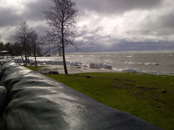 Super sandbags and Geotubes installed at Laurentia Beach October 2014 |
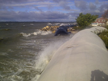 Geotubes located at Twin Beaches, Lake Manitoba, photo taken October 2014 |
Flooding on Lake St. Martin
In early spring the Fairford River Water Control Structure was already operating at full capacity to help reduce water levels on Lake Manitoba. In the February and March, Lake St. Martin levels were already high for that time of year. With wet conditions persisting across much of southern Manitoba for the month of June and with high water levels already evident for many of Manitoba's larger lakes, equipment was staged at Reach 1 of the Lake St. Martin emergency outlet channel in March. On June 25, 2014 Manitoba announced that the Lake St. Martin Emergency Outlet Channel (LSMEOC) would be reopened due to high lake levels caused by high rainfall through the late spring and early summer. The decision to reopen the LSMEOC was made prior to the rainfall event from June 27 to 30 that caused significant overland flooding and pushed the Assiniboine River and many other streams into flood stage.
Work began on July 2, 2014 to open the LSMEOC and it began operating on July 6 to increase outflow from Lake St. Martin and help lower lake levels from a peak of 803.6 feet to 803.0 feet by July 18.
LSMEOC opening, July 4, 2014
LSMEOC opening, July 7, 2014
Due to concerns of local stakeholders, LSMEOC was not opened to full capacity; only approximately one third of the 120 metre (36.57 feet) channel opening was removed. Flows through the Lake St. Martin Emergency Outlet Channel peaked at approximately 130.25 cms (4,600 cfs).
The partial opening was done to balance flood reduction benefits the channel provides to Lake St. Martin and the potential downstream impacts resulting from its operation. Even partially opened, the channel provided a significant flood reduction benefit, helping lower water levels on Lake St. Martin in spite of the high inflows from Lake Manitoba.
In November 2014, further work was done to open the channel to approximately half of its full width. The channel was not opened fully due to the commencement of frazil ice formation downstream on the Dauphin River. The LSMEOC remained partially open over the 2014/15 winter season.
Flooding on Lake Winnipegosis and the Waterhen River
Water flows into Lake Winnipegosis from the north slopes of the Riding Mountains to just south of Cedar Lake, and also from parts of eastern Saskatchewan. The main outlet from Lake Winnipegosis is the Waterhen River, which connects Lake Winnipegosis to the north basin of Lake Manitoba. At the start of the spring runoff in mid April the level of the lake rose due to persistent precipitation throughout the spring and increased tributary flows. The recorded peak mean daily water level occurred on July 1, 2014 at approximately 254.72 metres (835.70 feet), Adjusting for wind effects the wind eliminated peak level occurred around mid-July at approximately 254.29 metres (834.3 feet). By mid-October the wind eliminated lake level was estimated to be approximately 254.05 metres (833.5 feet).
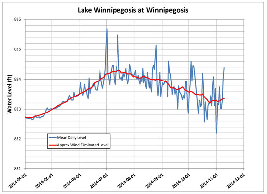
Lake Winnipegosis 2014 Summer Peak Level
Lake Winnipeg
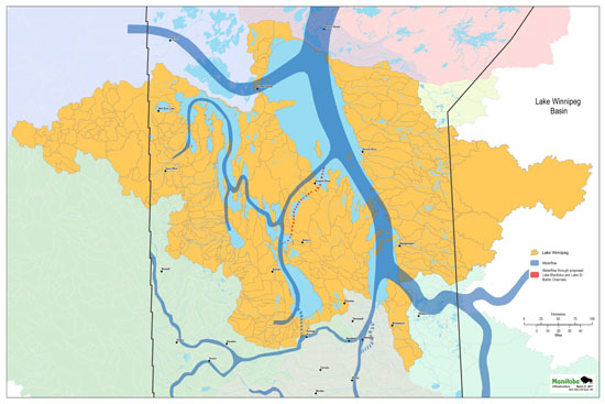
Lake Winnipeg Basin illustrating the drainage system and movement of water flow
In February 1966, an agreement was reached between the government of Manitoba and the government of Canada, allowing Manitoba Hydro to use Lake Winnipeg as a natural reservoir for hydroelectric development on the Nelson River.
The Lake Winnipeg Regulation Project was undertaken to achieve three main purposes:
- to mitigate the frequency and severity of flooding on Lake Winnipeg
- to mitigate low water levels (i.e. drought) on Lake Winnipeg
- to enhance power production on the Nelson River
Manitoba Hydro operates Lake Winnipeg Regulation in accordance with the Interim Licence and Supplementary Interim Licence for the Regulation of Water Levels for Power Purposes on Lakes Winnipeg, Playgreen, and Kiskittogisu.
Manitoba Hydro may regulate water levels in Lake Winnipeg to and between a maximum of 217.9 metres (715.0 feet) and a minimum of 216.7 metres (711.0 feet). When the level of Lake Winnipeg is above 217.9 metres (715.0 feet), Manitoba Hydro must operate the control structure at Jenpeg in such a manner to effect maximum discharge possible. When the level of Lake Winnipeg is below 216.7 metres (711 feet), Manitoba Hydro must operate outflow as ordered by the Minister responsible for The Water Power Act.
More information about this issue can be found at: https://www.gov.mb.ca/waterstewardship/licensing/lake_wpg_regulation.html
Like all lakes, water levels on Lake Winnipeg fluctuate depending on weather conditions in their drainage basins, inflows to the lake and the outflow capacity of the lake. Prior to regulation, Lake Winnipeg reached higher and lower water levels than what is experienced under the current water regime which narrows the range of water levels experienced on the lake.
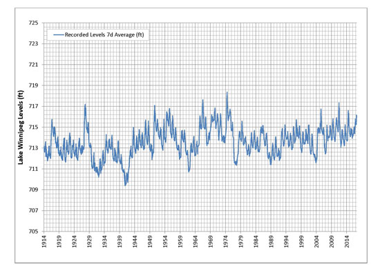
Recorded water levels on Lake Winnipeg from 1914 to 2017
Below is more detailed information on the four highest high-water years in recent years.
2005
Lake Winnipeg reached unusually high levels in 2005, due to major spring runoff and heavy summer rains. In the fall, the Manitoba government responded to requests to support municipalities in building dikes to provide protection from high waves and wind along the south basin of Lake Winnipeg. This included permanent dikes (upgrading existing dikes) and temporary flood protection measures (earthen dikes/sandbags). Two storms occurred on October 5, 2005 and November 16, 2005 that resulted in similar peak water levels with wind set-up on the west side of Lake Winnipeg. Significant damages occurred to the newly constructed dikes and there was significant erosion of unprotected shorelines. Residential ice damage also occurred due to freezing spray from waves crashing the shore. There were no reports of total failure or breaches in any of the dikes. The dikes were successful in protecting the communities of Gimli and Winnipeg Beach and a number of homes, cottages and businesses from flooding from these 2005 storm events.
2009
In 2009, Lake Winnipeg water level exceeded the top of operating range 217.9 metres (715.0 feet) from May 15th to September 4, 2009. Unseasonably strong wind storms in June and July 2009 caused significant damage to some of the dikes constructed between 2005 and 2007, especially in the Town of Winnipeg Beach.
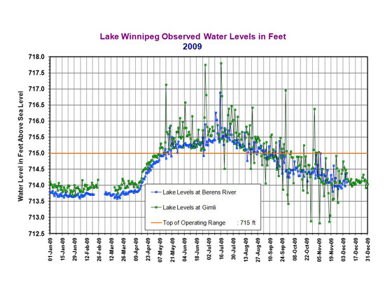
Lake Winnipeg Observed Water Levels in Feet - 2009
2010
In 2010, the lake water levels were higher than 217.9 metres (715 feet) between July 1 and December 25, 2010. The wind eliminated level was around 218.05 metres (715.4 feet) when a massive storm (also known as a weather bomb) hit on October 27, 2010.
The strength of the winds pushed levels to rise as high as 219.39 metres (719.8 feet) in the southern beaches, and significantly damaged parts of the dikes and caused some flooding and property damage along the south basin of Lake Winnipeg. A Disaster Financial Assistance (DFA) program was established to help with the repair costs of storm damage to residential properties and municipal structures.
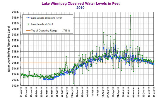
Lake Winnipeg Observed Water Levels in Feet - 2010
2011
In the flood of 2011, precipitation and runoff volumes hit record or near-record values in many portions of the basin that drains into Lake Winnipeg. The water level on Lake Winnipeg peaked at 218.5 metres (716.9 feet) around July 7, 2011. The levels remained higher than 217.9 metres (715 feet) between April 22 and October 2, 2011.
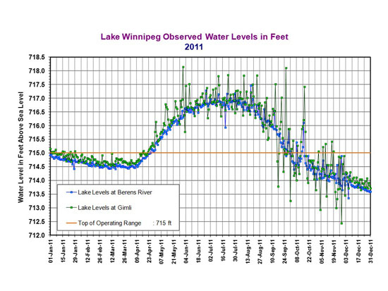
Lake Winnipeg Observed Water Levels in Feet - 2011