
Geoscience
Paleofloods in the Red River Basin
 DendochronologyPast FloodsClimate Change DendochronologyPast FloodsClimate Change |
Photo ListPublicationsPaleofloods home |
||
Past Floods in the Red and Assiniboine River Valleys
The rhythm of the Red has affected southern Manitoba since the end of the last glaciation.

The current Red River oak record extends back to AD 1286 and documents changes in environmental conditions over the last seven hundred years.
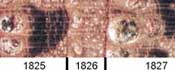
Extreme floods, such as the 1950 flood or larger, cause oak to develop distinctive anatomical markers, or ‘flood rings’, that can be used to identify older and previously unknown Red River floods. Tree rings provide an extended flood record for the lower Red River (between Winnipeg and Morris) that extends from AD 1648 to 1999. This technique has identified seven high-magnitude floods during the last 350 years: 1997, 1979, 1950, 1852, 1826, 1762 and 1747.
 Although the five most recent flood rings are coincident with known high-magnitude floods, signatures in 1747 and 1762 predate local instrumental and historical flood records and represent previously unknown floods. Flood rings also document Red River floods in North Dakota and Minnesota in AD 1510, 1538, 1658, 1682, 1726, 1727, 1741, 1747 and 1762.
Major Findings
- The 1826 flood was the most severe event since at least AD 1648.
- The risk of flooding has changed several times during the last 350 years. Although the mechanisms responsible for these changes are not yet understood, we clearly cannot assume that the pattern of recent flooding will continue indefinitely into the future.
- Future flood risks should use techniques that account for non-stationairity and non-randomness introduced by climatic and landscape changes.