
Geoscience
Surficial Geology
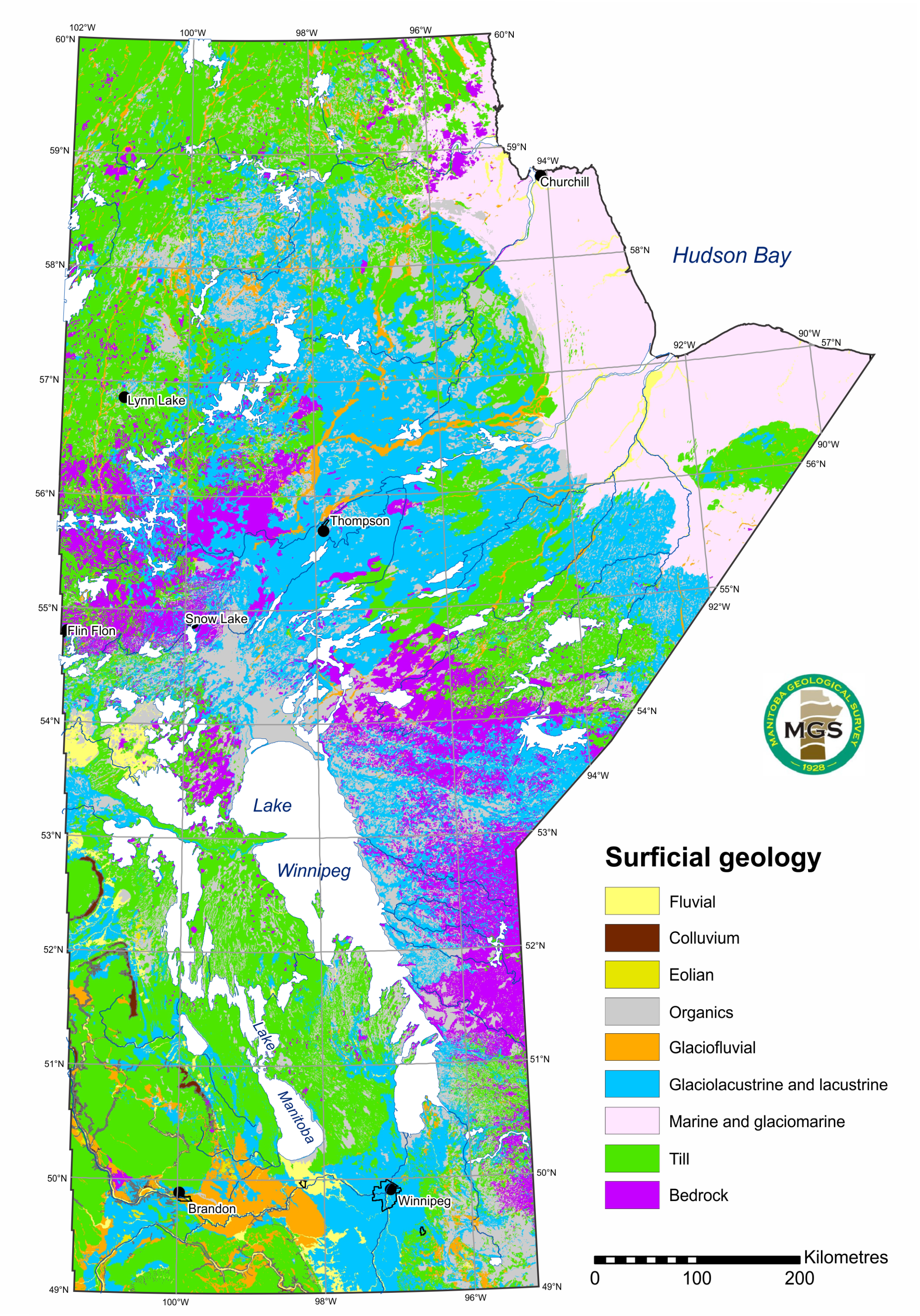
Surficial geology focuses on the description of the types and distributions of unconsolidated sediments across the landscape. Surficial-geological data is essential for the successful interpretation of ice flow and glacial history in Manitoba. This information is collected and maintained primarily in maps and databases. It is useful for mineral exploration, sand and gravel production, hazard assessment, and infrastructure and landuse planning.
Applications of Surficial geology data (PDF)
Jump to:
 Digital compilation of surficial point and line features
Current and completed projects
Digital capture of potential aggregate deposits
GeoFiles
GeoFile 9:Janssens, J. and Hodder, T.J. 2026: Manitoba till-matrix geochemistry compilation: inductively coupled plasma–mass spectrometry and inductively coupled plasma–optical emission spectroscopy data after a fusion digestion; Manitoba Business, Mining, Trade and Job Creation, Manitoba Geological Survey, GeoFile 9-2026, Microsoft® Excel® file.
GeoFile 8:
Gauthier, M.S. 2025: Manitoba till-matrix geochemistry compilation: visible gold grains in the heavy mineral (<2 mm) size-fraction; Manitoba Business, Mining, Trade and Job Creation, Manitoba Geological Survey, GeoFile 8-2025, Microsoft® Excel® file.
GeoFile 7:
Gauthier, M.S. 2025: Manitoba till-matrix geochemistry compilation: total carbonate of the silt plus clay (<63 μm) size-fraction; Manitoba Business, Mining, Trade and Job Creation, Manitoba Geological Survey, GeoFile 7-2025, Microsoft® Excel® file.
GeoFile 6:
Gauthier, M.S. 2023: Manitoba radiocarbon ages; Manitoba Economic Development, Investment and Trade, Manitoba Geological Survey, GeoFile 6-2023.
GeoFile 2:
Gauthier, M.S. 2025: Manitoba till-matrix geochemistry compilation: silt plus clay (<63 µm) size-fraction by inductively coupled plasma–mass spectrometry after an aqua-regia or modified aqua-regia digestion; Manitoba Business, Mining, Trade and Job Creation, Manitoba Geological Survey, GeoFile 2-2025, Microsoft® Excel® file.
2024–2026 releases
Scientific papers
Hodder, T.J., Gauthier, M.S., Ross, M., Kelley, S.E., Lian, O.B., Dalton, A.S., Finkelstein, S.A. 2024: Unravelling the fragmented sediment-landform assemblage in an area of thick Quaternary sediment, western Hudson Bay Lowland, Canada; Canadian Journal of Earth Sciences 61, 1156–1183, URL <https://doi.org/10.1139/cjes-2024-0018>.
Gauthier, M.S., Hodder, T.J., Dalton, A.S., Lian, O.B., Schaarschmidt, M., Ross, M., Väliranta, M., Finkelstein, S.A. 2024: Preservation of MIS 7 deglacial and nonglacial deposits near the edge of the Hudson Bay Lowland in Manitoba, Canada; Canadian Journal of Earth Sciences 61, 1184–1211, URL <https://doi.org/10.1139/cjes-2024-0019>.
Gauthier, M.S., Hodder, T.J., Dalton, A.S., Brewer, V., Lian, O.B., Finkelstein, S.A., Schaarschmidt, M., Mereghetti, A. 2025: South-central Laurentide Ice Sheet dynamics and the formation of proglacial Lake Vita during MIS 3; Quaternary Research 123, 83–105, URL <https://doi.org/10.1017/qua.2024.34>.
Gauthier, M.S., Hodder, T.J., Hathaway, J., Ross, M., Schaarschmidt, M., Lian, O. B., Finkelstein, S.A. 2026: Extending the western Hudson Bay Lowland Quaternary stratigraphy, in Manitoba Canada, to at least Marine Isotope Stage 10; Canadian Journal of Earth Sciences 63, URL < https://doi.org/10.1139/cjes-2025-0027>.
Hodder, T.J., Gauthier, M., Ross, M., Dalton, A.S., Schaarschmidt, M., Lian, O.B., Finkelstein, S.A., Grunsky, E.C., Jennings, A.E. 2026: Laurentide Ice Sheet dynamics across multiple glacial-interglacial cycles from Quaternary stratigraphic records in central Canada; Canadian Journal of Earth Sciences 63, URL <https://doi.org/10.1139/cjes-2025-0098>.
Report of Activities
Hodder, T.J. and Lian, O.B. 2024: Reconnaissance-scale Quaternary geology investigations to support lithium exploration in southeastern Manitoba (parts of NTS 52L, M, 62P, 63A); in Report of Activities 2024, Manitoba Economic Development, Investment, Trade and Natural Resources, Manitoba Geological Survey, p. 200–208.
Gauthier, M.S. and Bergen, S. 2024: Quaternary site data, till composition and ice-flow indicators between the North Knife River and the Seal River, and in the Gross Lake area, far northeastern Manitoba (parts of NTS 54L10–15, 54M5, 6, 12); in Report of Activities 2024, Manitoba Economic Development, Investment, Trade and Natural Resources, Manitoba Geological Survey, p. 209–218.
Rentz, J.W., Marks, J. Frederiksen, A. and Guerard, R. 2024: Geophysical imaging of a buried gravel deposit in the Rural Municipality of Taché, southeastern Manitoba (part of NTS 62H15); in Report of Activities 2024, Manitoba Economic Development, Investment, Trade and Natural Resources, Manitoba Geological Survey, p. 219–225.
Hodder, T.J. and Janssens, J. 2025: Till sampling strategies and surficial geology mapping in the Bird River greenstone belt area, southeastern Manitoba (parts of NTS 52L5, 6, 11, 12); in Report of Activities 2025, Manitoba Business, Mining, Trade and Job Creation, Manitoba Geological Survey, p. 174–180.
Gauthier, M.S. 2025: Complex Quaternary geology around Grunthal, south-central Manitoba (parts of NTS 62H7); in Report of Activities 2025, Manitoba Business, Mining, Trade and Job Creation, Manitoba Geological Survey, p. 181–190.
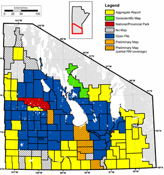
Rentz, J.W., Wheadon, B. and Janssens, J. 2025: Current mapping and assessment of granular-aggregate deposits in Manitoba; in Report of Activities 2025, Manitoba Business, Mining, Trade and Job Creation, Manitoba Geological Survey, p. 191–194.
Bodnar, M.M., Voinot, A., Leybourne, M., Gauthier, M.S., Trott, M. 2025: Exploring the use of geoanalytics to enhance landscape-integrated geochemical interpretations of lake sediments at the regional scale in northern Manitoba (NTS 64F, G, J, K); in Report of Activities 2025, Manitoba Business, Mining, Trade and Job Creation, Manitoba Geological Survey, p. 195–202.
Data
Hodder, T.J. and Gauthier, M.S. 2025: Quaternary site, till composition and ice-flow indicator data for the Little Churchill to Churchill rivers area, north-eastern Manitoba (part of NTS 54E); Manitoba Business, Mining, Trade and Job Creation, Manitoba Geological Survey, Open File OF2025-1, 5 p., 6 appendices.
Hodder, T.J. and Gauthier, M.S. 2025: Quaternary site, till composition and ice-flow indicator datasets in the Nelson River Estuary–Black Duck River area, northeastern Manitoba (parts of NTS 54A, B, C, F); Manitoba Business, Mining, Trade and Job Creation, Manitoba Geological Survey, Open File OF2025-2, 7 p., 8 appendices.
Hodder, T.J. 2025: Till-matrix geochemistry data from the 2022–2024 field seasons in southeastern Manitoba (parts of NTS 52L, 62P, 63A); Manitoba Business, Mining, Trade and Job Creation, Manitoba Geological Survey, Data Repository Item DRI2025005, Microsoft® Excel® file.
Hodder, T.J. 2025: Gold and indicator-mineral data derived from glacial sediments (till) in southeastern Manitoba (parts of NTS 52L, M, 62P, 63A); Manitoba Business, Mining, Trade and Job Creation, Manitoba Geological Survey, Data Repository Item DRI2025006, Microsoft® Excel® file.
Gauthier, M.S. 2025: Gold, rare element and other indicator-mineral data derived from glacial sediments (till) in between the North Knife River and the Seal River, and in the Gross Lake area, far northeastern Manitoba (parts of NTS 54L10–15, 54M5, 6, 12); Manitoba Business, Mining, Trade and Job Creation, Manitoba Geological Survey, Data Repository Item DRI2025017, Microsoft® Excel® file.
Gauthier, M.S. 2025: Till geochemistry in between the North Knife River and the Seal River, and in the Gross Lake area, far northeastern Manitoba (parts of NTS 54L10–15, 54M5, 6, 12); Manitoba Business, Mining, Trade and Job Creation, Manitoba Geological Survey, Data Repository Item DRI2025030, Microsoft® Excel® file.
Gauthier, M.S. 2025: 2024 granular-aggregate field visits—Quaternary site data, sample composition and ice-flow indicators—in southern Manitoba (parts of NTS 62H7, 10, 15, 16, 62I2, 6); Manitoba Business, Mining, Trade and Job Creation, Manitoba Geological Survey, Data Repository Item DRI2025025, Microsoft® Excel® file.
Hodder, T.J. 2024: Field-based ice-flow–indicator data collected during the 2023 and 2024 field seasons in southeastern Manitoba (parts of NTS 52L, M, 62P); Manitoba Economic Development, Investment, Trade and Natural Resources, Manitoba Geological Survey, Data Repository Item DRI2024010, Microsoft® Excel® file.
Hodder, T.J. 2024: Gold and indicator-mineral data derived from glacial sediments (till) in southeastern Manitoba (parts of NTS 52L, 62P, 63A); Manitoba Economic Development, Investment, Trade and Natural Resources, Manitoba Geological Survey, Data Repository Item DRI2024004, Microsoft® Excel® file.
Current projects
- Till sampling and Quaternary stratigraphy of the Machichi–Kettle rivers area
- Gillam area (parts of NTS 54D)
- Kasmattama highlands, Hudson Bay Lowland
- Pilot Mound/Morden
- Western Fox River belt, NTS 53M15 and 16
- Ongoing carbonate dispersal analyses
- Omarolluk (Omar) erratics
Completed projects
- Arden (NTS 62J6)
- Gauer Lake to Wishart Lake (NTS 64H)
- Knee Lake–Oxford Lake (NTS 53L)
- Lynn Lake area (parts of NTS 64F3, 4; 64C9, 11, 12, 14, 15, 16; 64B12)
- Northeastern-most Manitoba
- Southern Indian Lake (parts of 64G)
- Updated post-glacial marine limits along western Hudson Bay, central mainland Nunavut and northern Manitoba
To search for or download free publications related to all quaternary and surficial projects in Manitoba, please visit the Bibliography of Manitoba Geology.
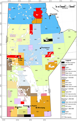
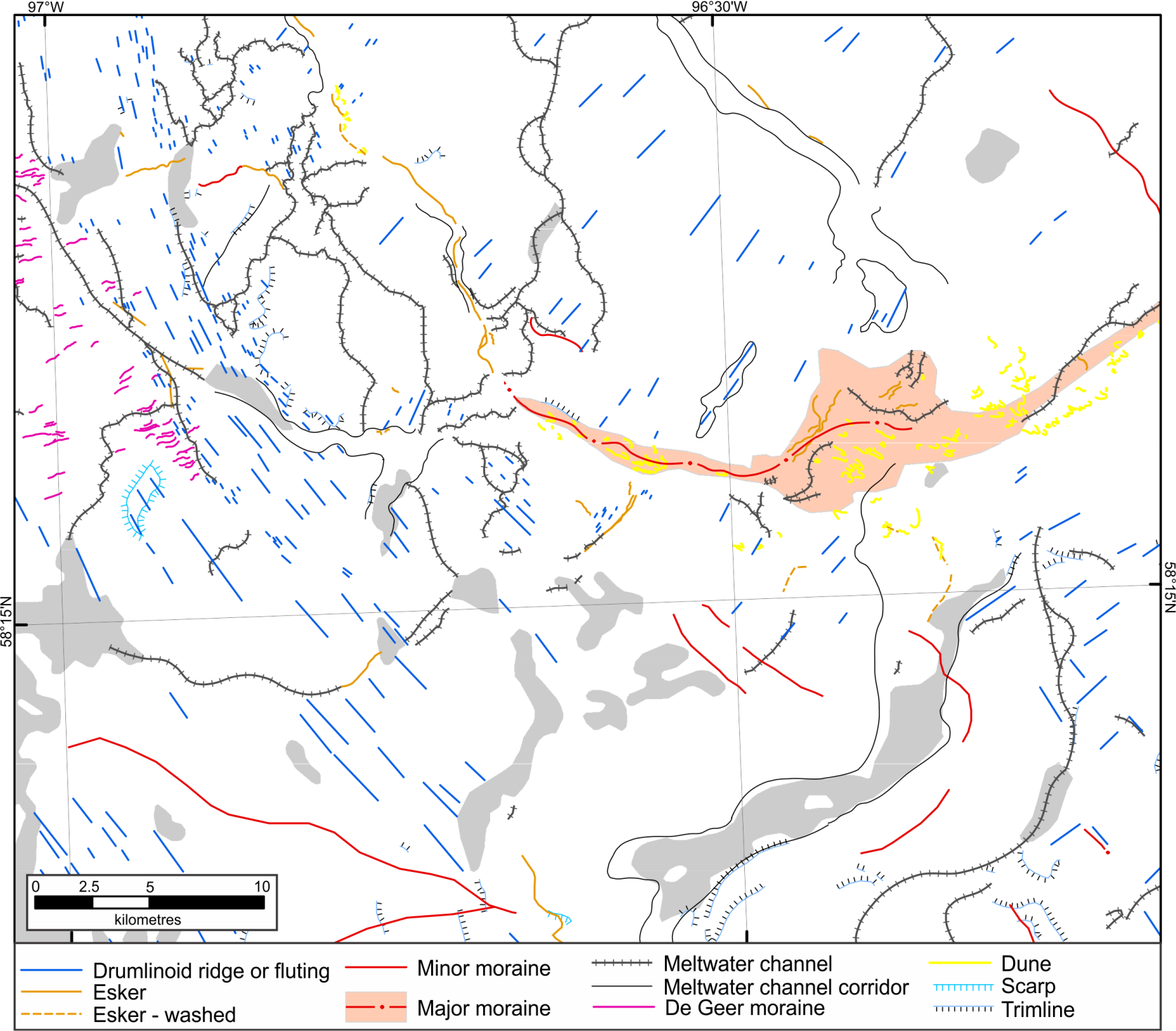
Surficial map compilationsFor more information, visit the Surficial Geology Compilation Map Series web page. How to create a surficial map (PDF)
Cross-sectionsCross-sections maps can be downloaded off of the Phanerozoic Stratigraphy page.
|
 |