
Geoscience
Paleofloods in the Red River Basin
 DendochronologyPast FloodsClimate Change DendochronologyPast FloodsClimate Change |
Photo ListPublicationsPaleofloods home |
||
"The forts now stand like a castle of romance in the midst of an ocean of deep contending currents, the water extending for at least a mile behind them, and they are thereby only approachable by boats and canoes."
Francis Heron, describing the Red River flood of 1826.
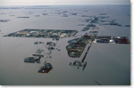
| More than any other large city in Canada, Winnipeg has suffered repeated physical, social and economic injury due to severe flooding. Although Winnipeg largely escaped the "flood of the century" in 1997 without bearing serious damage, the Red River still forced the evacuation of over 28,000 people in Manitoba and had a direct economic impact of roughly $500 million. Similar large floods threatened Winnipeg in 1979 and 1950 and caused extensive damage to the fledgling Red River Settlement in 1861, 1852 and 1826. |
|
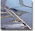
Red River Floodway, Manitoba, during the 1997 flood
|
Flooding is a dynamic process that is affected by geomorphic, geological and climatic change. Although these changes can occur very slowly, they may be very significant when considered over the time horizons used in the design of flood protection structures (typically between 100-1,000 years). The perspective offered by geoscientific research allows us to understand the subtle environmental processes that can either increase or reduce flood hazards over the long term. |
| Following the 1997 Red River flood, the Manitoba Geological Survey (MGS) and Geological Survey of Canada (GSC) initiated a multi-disciplinary research program on flood hazards in the Red River Basin. The main objective of this program was to provide a better understanding of the history and causes of past extreme floods and to determine how the risk of flooding changes over time. | |
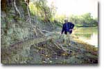
The project has focused on several separate lines of investigation, including efforts to develop limnological flood records from Lake Winnipeg as well as studies of the alluvial geomorphology and sedimentology along the Red River. However, this website focuses on the use of annual tree rings to develop records of past flooding and climatic change in the Red River basin that extend back several centuries.