
McArthur Falls Generating Station
|
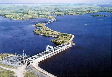
The McArthur Falls Generating Station is located approximately 120 km (75 miles) northeast of the City of Winnipeg and 42 km (26 miles) upstream of Lake Winnipeg on the Winnipeg River. |
The McArthur Falls Generating Station consists of a powerhouse, spillway and dykes and has a name plate capacity of 59.7 MW (80,000 hp). The station, constructed between 1952 and 1955, is the newest and smallest of the six generating stations operating on the Winnipeg River.
The station components include an eight unit powerhouse with east gravity structure, an eight bay gated spillway with east and west gravity structures and a total of fifteen dykes. The dykes are divided by the spillway and powerhouse into the east dykes with a total length of 0.37 km (0.23 miles), the centre dykes with a total length of 0.58 km (0.36 miles) and the west dykes with a total length of 8.8 km (5.5 miles). The dam and the dykes impound Lac Du Bonnet.
Licences:
- Fourth Short Term Extension Licence (2025 to 2026)
- Third Short Term Extension Licence (2020-2025)
- Second Short Term Extension Licence (2015 to 2020)
- Short Term Extension Licence (2005 to 2015)
- Final Licence (1955 to 2005)
Supporting Documentation:
- McArthur Falls GS Short Term Extension Licence Renewal Application (November 2024)
- McArthur Falls GS Renewal Licence Request Support Report (December 2023)
- McArthur Falls GS Renewal Licence Request Drawing (December 2023)
- McArthur Falls GS Short Term Extension Licence Renewal Application (March 2020)
- McArthur Falls Generating Station Licence Implementation Guide for Water Levels (2017)
- McArthur Generating Station Short Term Extension Licence Renewal Application, June 2015
- McArthur Falls Generating Station Short Term Licence Extension Application - Supporting Documentation (2010)
- McArthur Falls GS Renewal Licence Request (February 1999)